 Filter: County of Grant
Filter: Subject of human settlements
Filter: Year of 1800-1899
Filter: County of Grant
Filter: Subject of human settlements
Filter: Year of 1800-1899

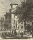
| Date: | 1885 |
|---|---|
| Description: | Caption reads: "First Soldier's Monuments Erected in the US — Lancaster Wis". There is a cannon and cannon balls on the lawn to the left of the monuments. |
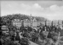
| Date: | 1868 |
|---|---|
| Description: | Elevated view of the Grant County Soldier's Monument. A group of people are standing around the monument. A large building is in the background. Caption at... |
| Date: | 1865 |
|---|---|
| Description: | Stereograph elevated view of a home in Lancaster. |
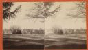
| Date: | 1865 |
|---|---|
| Description: | Stereograph of Lancaster from behind a wooden fence. |
| Date: | 1865 |
|---|---|
| Description: | Stereograph view looking downhill towards the three-story Farwell Hotel in Lancaster. |
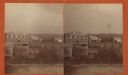
| Date: | 1865 |
|---|---|
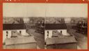
| Description: | Stereograph view looking downhill towards Lancaster, with the Congregational Church to the right. |
| Date: | 1865 |
|---|---|
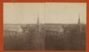
| Description: | Stereograph of an elevated view of Court House Square in Lancaster. |
| Date: | 1864 |
|---|---|
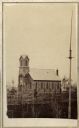
| Description: | Slightly elevated view across grounds towards the Trinity Episcopal Church, built in 1864. |
| Date: | 1880 |
|---|---|
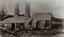
| Description: | A straw lead furnace, an open hearth furnace where lead sulphite (Galena) was roasted. Located on the Rountree branch of the Little Platte River, Richard S... |
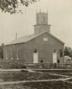
| Date: | 1880 |
|---|---|
| Description: | A view of the First Methodist Church. Two men are standing in front of the church behind a fence. |
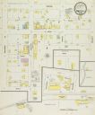
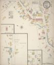
| Date: | 12 1899 |
|---|---|
| Description: | Sanborn map of Montfort, population 800. |
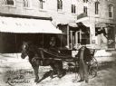
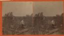
| Date: | 1894 |
|---|---|
| Description: | Man in coat and top hat holding the harness of a horse attached to a buggy. |
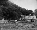
| Date: | 1886 |
|---|---|
| Description: | Exterior view of the Potosi Brewery at about the time Adam Schumacher took over the operation. Children and adults can be seen near a fence and in horse-dr... |
| Date: | 1884 |
|---|---|
| Description: | Sanborn map showing the main street of Potosi, Wisconsin, with an inset for the Potosi Brewery. |
| Date: | 1846 |
|---|---|
| Description: | A view of the college and surrounding green space at Saint Clara Academy. Saint Clara Academy moved to River Forest, Illinois in 1922, and since 1970 has g... |

| Date: | 1835 |
|---|---|
| Description: | Plat for a proposed Sinsinawa City (never built), in Grant County, Wis. When it became clear in the mid-1830s that Wisconsin Territory would be established... |

| Date: | 1857 |
|---|---|
| Description: | Relief shown by hachures. "Lith. of Ed. Mendel, Chicago." Shows townships and sections, rivers, roads, railroads, houses, flour mills, saw mills, furnaces... |

| Date: | 1848 |
|---|---|
| Description: | Pen-and-ink on paper. Includes certifications signed by "Geo R. Bluntz, District Survey of Grant Co. W.T." and Ben C. Eastman. |

| Date: | 1850 |
|---|---|
| Description: | This map of Cassville shows plat of town, roads, and the Mississippi River. Relief is shown by hachures. The map includes an inset map of a Plat of townshi... |

| Date: | 1850 |
|---|---|
| Description: | This map of Cassville shows plat of the town, roads, landings and public wharfs and the Mississippi River. |
If you didn't find the material you searched for, our Library Reference Staff can help.
Call our reference desk at 608-264-6535 or email us at: