 Filter: County of Lafayette
Filter: Creator Name of Unknown
Filter: Year of 1800-1899
Filter: County of Lafayette
Filter: Creator Name of Unknown
Filter: Year of 1800-1899
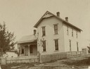
| Date: | 1895 |
|---|---|
| Description: | Front entrance to the Methodist Episcopal Church, the first parsonage built at Fayette. |
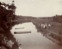
| Date: | 1898 |
|---|---|
| Description: | Elevated view of a mill pond, with a group of three women and a man standing near the shoreline on the right. |
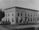
| Date: | 1896 |
|---|---|
| Description: | Exterior view of the City Hotel with a group of people posed near its entrance. |

| Date: | 1874 |
|---|---|
| Description: | Map of New Diggings — inset map in bottom right corner of "Benton & New Diggings" map, on page 11 of "Atlas of Lafayette County Wisconsin," a collect... |

| Date: | 1836 |
|---|---|
| Description: | A series of ink, watercolor, and pencil on paper, hand-drawn maps of the townships of Darlington and Gratiot in Lafayette County, Wisconsin, showing the to... |

| Date: | 1830 |
|---|---|
| Description: | An ink on paper, hand-drawn map, showing the wagons roads that travel through Lafayette County, traveling between Galena, Illinois, and Mineral Point, Wisc... |

| Date: | 1836 |
|---|---|
| Description: | This map of Belmont includes notarization from the justice of the peace of Iowa County, May 15, 1836, acknowledging John Atchison as proprietor of Belmont ... |

| Date: | 1852 |
|---|---|
| Description: | Sixth plate daguerreotype of Azel Parkhurst Ladd (1811-1854). Ladd was the Wisconsin state superintendent of public instruction in 1852. Oval-framed quarte... |

| Date: | 1857 |
|---|---|
| Description: | This map shows lot numbers, lot dimensions (in chains and links), and a mineral reservation for use of proprietors. Includes certifications signed in Sept.... |
If you didn't find the material you searched for, our Library Reference Staff can help.
Call our reference desk at 608-264-6535 or email us at:
