 Filter: County of Lafayette
Filter: Subject of cities and towns
Filter: County of Lafayette
Filter: Subject of cities and towns

| Date: | 1904 |
|---|---|
| Description: | Map shows townships and sections, landownership and acreages, roads, railroads, post offices, and farms. On the top, bottom, and sides of map are advertise... |
| Date: | 1925 |
|---|---|
| Description: | View downhill towards a central business district. A restaurant and ice cream parlor are on the right side of the road, and a general store and gas pump ar... |
| Date: | 1925 |
|---|---|
| Description: | View of an intersection in the central business district. On the left is the Thomas Knewstubb general store, with a gas pump for Red Crown Gasline out in ... |

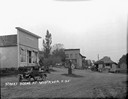
| Date: | 1911 |
|---|---|
| Description: | A view of the central business district in a rural community. A group of people on the landing of a store. A cart with a pair of horses at hitching post. |

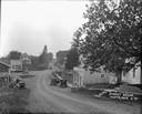
| Date: | 1925 |
|---|---|
| Description: | A view of a street in the central business district. A restaurant with a group of men in front on the left. Three children with a wagon on the right. A hou... |

| Date: | 1911 |
|---|---|
| Description: | Three-quarter view of the Methodist Evangelical Church on a hillside. It has a belfry with no steeple and windows shaped like elongated pentagons. |

| Date: | 1925 |
|---|---|
| Description: | View of a public school on a hilltop, which is a one-story brick building with a chimney and a belfry. |
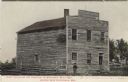
| Date: | |
|---|---|
| Description: | Colorized photographic postcard view of the First Capitol, which is an unpainted wood frame building, with a log fence and a man standing in front. Caption... |
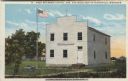
| Date: | |
|---|---|
| Description: | Colorized view of the First State Capitol, which is a wood frame building, painted white, with a flag and a plaque in front. Caption reads: "First Wisconsi... |

| Date: | 1912 |
|---|---|
| Description: | Photographic postcard view of a central business district. On the left is a bank, and a "Place to Eat." Horses and buggies are further down the block. Capt... |

| Date: | 1908 |
|---|---|
| Description: | Elevated photographic view of the town of Blanchardville with the commercial district on the left, and residential neighborhoods on the right. The river is... |
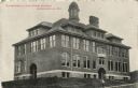
| Date: | |
|---|---|
| Description: | Exterior view of a large brick high school with a belfry and large glass windows. Caption reads: "Blanchardville High School Building, Blanchardville, Wis.... |

| Date: | |
|---|---|
| Description: | Photographic postcard view of the interior of the Lutheran Church. Pews and hymnals are on each side, and flags are at the altar. A piano is near the pulpi... |

| Date: | 1836 |
|---|---|
| Description: | This map of Belmont includes notarization from the justice of the peace of Iowa County, May 15, 1836, acknowledging John Atchison as proprietor of Belmont ... |

| Date: | 1882 |
|---|---|
| Description: | Plat map of the village of Dunbarton, received by the Lafayette County Register's Office on September 22, 1892. Certification by the surveyor, Albert Pool,... |

| Date: | 1855 |
|---|---|
| Description: | This map is ink, pen, and watercolor on paper and shows plat of the town, local streets, lots by number, U.S. subdivisions in red lines, Mineral Point Rail... |

| Date: | 1910 |
|---|---|
| Description: | Aerial view along river toward Darlington. Caption reads: "Bird's-Eye View, Darlington, Wis." |

| Date: | 1910 |
|---|---|
| Description: | View across top of the Pecatonica River dam towards the opposite shoreline. Caption reads: "The Dam at Darlington, Wis." |
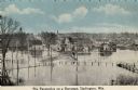
| Date: | 1910 |
|---|---|
| Description: | Elevated view of the Pecatonica River at the bridge. The river is flooding the town. Caption reads: "Pecatonica River on a Rampage, Darlington, , Wis." |
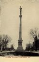
| Date: | 1910 |
|---|---|
| Description: | View of Soldier's Monument. Caption reads: "Soldier's Monument, Darlington, Wis." |
If you didn't find the material you searched for, our Library Reference Staff can help.
Call our reference desk at 608-264-6535 or email us at: