 Filter: County of Marinette
Filter: Subject of human settlements
Filter: County of Marinette
Filter: Subject of human settlements

| Date: | 1920 |
|---|---|
| Description: | A winter scene showing two men standing behind the blade, on either side of the cab, of a Caterpillar Wausau-Plow Snow V-Plow. They are removing snow from ... |

| Date: | |
|---|---|
| Description: | Aerial view of harbor. In the foreground is a lighthouse and breakwaters. Bridges cross the harbor, and there are factory and industrial buildings near the... |

| Date: | |
|---|---|
| Description: | Aerial view of Marinette Harbor looking out towards Lake Superior. A lighthouse and breakwater extend out into the lake. Industrial buildings, cranes, and ... |

| Date: | 1965 |
|---|---|
| Description: | This map shows streets, churches, schools, wards, railroads, parks and fields, cemeteries, Historical Museum, Yacht Basin & Marina, and Marinette General H... |

| Date: | 1912 |
|---|---|
| Description: | This blueprint manuscript map shows selected buildings, roads, and the Peshtigo River. |

| Date: | 1920 |
|---|---|
| Description: | This map shows a small island in the Menominee River and includes a survey table and certification. |

| Date: | 1905 |
|---|---|
| Description: | This photocopied map shows landownership, roads, railroads, rural mail routes, churches, school houses, cemeteries, and townships. The map includes adverti... |

| Date: | 1912 |
|---|---|
| Description: | Marinette County, Township 37 N., Range 20 E. |
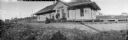
| Date: | |
|---|---|
| Description: | Panoramic view of four men and a child standing in front of the station of the Wisconsin & Michigan Railroad. One of the men is crouching near two handcars... |

| Date: | 1912 |
|---|---|
| Description: | A portion of a plat map of Marinette County showing township 30 N., range 21 E., and part of township 29 N., range 21 E. |
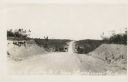
| Date: | |
|---|---|
| Description: | View down a dirt road stretching over a rolling hill. The land around it is clear of trees. Machinery is on the side of the road. Caption reads: "U.S. Hwy ... |
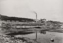
| Date: | 1922 |
|---|---|
| Description: | View across water towards the Niagara Paper Mill. |

| Date: | 1907 |
|---|---|
| Description: | View towards people sitting and standing near the front gates to the Chautauqua. Flags are on the arches. Caption reads: "Entrance to Chautauqua, Marinette... |
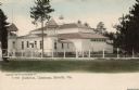
| Date: | 1905 |
|---|---|
| Description: | Exterior view of the Chautauqua auditorium and the surrounding fence. Caption reads: "Auditorium, Chautauqua, Marinette, Wis." |

| Date: | 1910 |
|---|---|
| Description: | Exterior view of the Hotel Marinette. There is a barber pole on the corner, and pedestrians are in the street. Caption reads: "Hotel Marinette, Marinette, ... |

| Date: | 1912 |
|---|---|
| Description: | View looking across to the left at a city block of storefronts, and a church in the distance. A man is standing in the street in the right foreground. Capt... |
| Date: | |
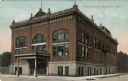
|---|---|
| Description: | Exterior view of the Marinette Opera House on a street corner. Caption reads: "Opera House, Marinette, Wis." |

| Date: | 1917 |
|---|---|
| Description: | Exterior view of a church with a bell tower in the corner, and large, stained-glass windows. Caption reads: "Baptist Church, Marinette, Wis." |

| Date: | |
|---|---|
| Description: | View down street toward a church on a street corner. Caption reads: "Presbyterian Church, Marinette, Wis." |

| Date: | 1917 |
|---|---|
| Description: | Exterior view of the church in a residential neighborhood. Caption reads: "M.E. Church, Marinette, Wis." |
If you didn't find the material you searched for, our Library Reference Staff can help.
Call our reference desk at 608-264-6535 or email us at: