 Filter: County of Marinette

| Date: | 1910 |
|---|---|
| Description: | Photographic postcard view of High Falls. Caption reads: "High Falls, Crivitz, Wis." |

| Date: | |
|---|---|
| Description: | A man in overalls stands in a cornfield looking up at the tall stalks. |

| Date: | 12 17 1957 |
|---|---|
| Description: | Carferry slip with pilings in the foreground, and a shoreline in the background. The pier is made of timbers. In the background on the left is a factory wi... |

| Date: | 12 17 1957 |
|---|---|
| Description: | View of icy Lake Michigan from Ogden Street Bridge. There are piles of coal on the left and right, and what may be a jetty in the far distance. |

| Date: | 1920 |
|---|---|
| Description: | A winter scene showing two men standing behind the blade, on either side of the cab, of a Caterpillar Wausau-Plow Snow V-Plow. They are removing snow from ... |

| Date: | |
|---|---|
| Description: | Aerial view of harbor. In the foreground is a lighthouse and breakwaters. Bridges cross the harbor, and there are factory and industrial buildings near the... |

| Date: | |
|---|---|
| Description: | Aerial view of Marinette Harbor looking out towards Lake Superior. A lighthouse and breakwater extend out into the lake. Industrial buildings, cranes, and ... |

| Date: | 1965 |
|---|---|
| Description: | This map shows streets, churches, schools, wards, railroads, parks and fields, cemeteries, Historical Museum, Yacht Basin & Marina, and Marinette General H... |

| Date: | 1912 |
|---|---|
| Description: | This blueprint manuscript map shows selected buildings, roads, and the Peshtigo River. |
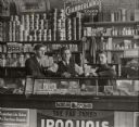
| Date: | 1910 |
|---|---|
| Description: | Three men posing behind the counter of a grocery store. Canned goods and jars of candy on the shelves behind them on the left, and pharmaceuticals are on t... |
| Date: | 1890 |
|---|---|
| Description: | A group of men sharing a meal at a fishing camp near Thunder Lake. |

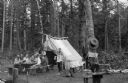
| Date: | |
|---|---|
| Description: | Group portrait of men at a fishing camp in the woods near Thunder Lake. Creels are hanging near long bamboo fishing poles leaning against trees. |

| Date: | 1920 |
|---|---|
| Description: | This map shows a small island in the Menominee River and includes a survey table and certification. |

| Date: | 2000 |
|---|---|
| Description: | This map shows Wisconsin Public Service Corporation property, special regulation areas, public boat landings, roads, parks, and other recreation areas. Ins... |

| Date: | 1905 |
|---|---|
| Description: | This photocopied map shows landownership, roads, railroads, rural mail routes, churches, school houses, cemeteries, and townships. The map includes adverti... |

| Date: | 1912 |
|---|---|
| Description: | Marinette County, Township 37 N., Range 20 E. |
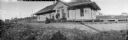
| Date: | |
|---|---|
| Description: | Panoramic view of four men and a child standing in front of the station of the Wisconsin & Michigan Railroad. One of the men is crouching near two handcars... |

| Date: | 10 07 1951 |
|---|---|
| Description: | A group of survivors of the Peshtigo Fire of 1871 are gathered in front of the Peshtigo Fire historical marker. The marker dedication coincided with the 80... |

| Date: | 1912 |
|---|---|
| Description: | A portion of a plat map of Marinette County showing township 30 N., range 21 E., and part of township 29 N., range 21 E. |
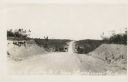
| Date: | |
|---|---|
| Description: | View down a dirt road stretching over a rolling hill. The land around it is clear of trees. Machinery is on the side of the road. Caption reads: "U.S. Hwy ... |
If you didn't find the material you searched for, our Library Reference Staff can help.
Call our reference desk at 608-264-6535 or email us at: