 Filter: County of Menominee
Filter: Year of 1900-1999
Filter: Year of 1970-1979
Filter: County of Menominee
Filter: Year of 1900-1999
Filter: Year of 1970-1979
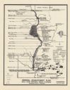
| Date: | 1974 |
|---|---|
| Description: | This map is a 9 part map detailing various parts of Menominee County, Wisconsin. Page 1 of the map shows federal aid control in the county and was used by ... |

| Date: | 1970 |
|---|---|
| Description: | This map shows land owned by Menominee Enterprise Inc., land sold to Menominee shareholders, and land sold to non-Menominees. The map also includes water a... |
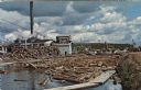
| Date: | 1972 |
|---|---|
| Description: | View of a log jam on the Wolf River next to a saw mill. Caption on back reads: "first built in 1908 . . . 20,000,000 feet lumber cut a year . . . largest i... |

| Date: | 1972 |
|---|---|
| Description: | Text on back reads: "Menominee Indians . . . Indian family chief, mother, daughter, at Wolf River Falls, Neopit, Wis." |

| Date: | 07 08 1972 |
|---|---|
| Description: | Text on reverse reads: "Menominee Chief in priceless full head dress of rare Eagle feathers. Neopit, Wis." A native American man stands with his arms cross... |
If you didn't find the material you searched for, our Library Reference Staff can help.
Call our reference desk at 608-264-6535 or email us at: