 Filter: County of Oneida
Filter: Year of 1900-1999
Filter: County of Oneida
Filter: Year of 1900-1999
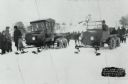
| Date: | 01 31 1926 |
|---|---|
| Description: | Winter scene of early snowmobile race at Rangeline Lake. Bill Neu (right), winner, Harold Hansen (left). Special conversion kits were available which allow... |

| Date: | 01 1969 |
|---|---|
| Description: | A map of Oneida county, which includes a small drawing of a hodag. |
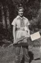
| Date: | 1950 |
|---|---|
| Description: | Sue Ann Hackett standing outdoors in her first-prize Daniel Boone costume, along with badge prize attached to her belt. Sue Ann is holding a sign on a stic... |

| Date: | 1950 |
|---|---|
| Description: | Margo Pirie and Sue Ann Hackett on an outdoor camping trip. They are seated near a campfire with a tent in the background. |

| Date: | 1950 |
|---|---|
| Description: | Sue Ann Hackett kneeling and holding a tin cup on an outdoor camping trip. There is a tarp in the foreground with dishes and food containers. Birch trees a... |

| Date: | 1950 |
|---|---|
| Description: | Close-up of a young girl wearing a bandana on her head sitting in a boat and removing a fish she has caught from the hook. Another girl is behind her holdi... |
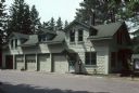
| Date: | 1991 |
|---|---|
| Description: | Exterior view of the ranger station at 7271 Main Street. |

| Date: | 1962 |
|---|---|
| Description: | This map shows roads, golf courses, ski areas, boat landings, camp sites, waysides, parks, beaches, scenic views, virgin timber tracts, airports, boys and ... |

| Date: | 1900 |
|---|---|
| Description: | Photographic postcard of the James G. Dunn Grocery, with William John Dunn standing on the left and Maggie (O'Hare) Dunn on the right. Handwritten on the... |

| Date: | 1900 |
|---|---|
| Description: | This map shows logging roads, railroads with spur lines, trails, rapids, lumber camps, Indian villages, summer resort, lakes, rivers, and ponds. |

| Date: | 1940 |
|---|---|
| Description: | This map shows lakes, roads, car trails, foot trails, railroads, resorts and camps, and fire towers. The map includes an inset location map and pictorial d... |
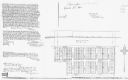
| Date: | 1996 |
|---|---|
| Description: | This photocopy plat map shows "old" Pennington, a village situated in section 26 of township 37 north, range 10 east, alongside the Minneapolis, Sault Ste ... |
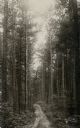
| Date: | 1909 |
|---|---|
| Description: | View up a dirt path leading through a pine forest. Caption reads: "Northern Wisconsin Pine Forest, Near Hazelhurst, Wis." |

| Date: | 1967 |
|---|---|
| Description: | A family looking at a sculpture of a Hodag in a glass case at the Rhinelander Logging Museum. |
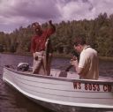
| Date: | 1963 |
|---|---|
| Description: | A man is standing in a boat on Pine Lake, holding up a muskellunge he has caught. Another man is sitting in the boat holding a camera to take a photograph ... |
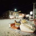
| Date: | 01 1968 |
|---|---|
| Description: | Groups of people are walking or standing downtown along the snow-covered street at night. Snowmobiles are parked in the right foreground. A banner stretchi... |
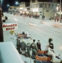
| Date: | 01 1968 |
|---|---|
| Description: | Elevated view of a crowd of people with snowmobiles standing on both sides of a snowy street downtown. There is a sign for a barbershop on the left, and a ... |
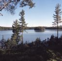
| Date: | 09 1971 |
|---|---|
| Description: | Elevated view from forested hill towards Carrol Lake. |

| Date: | 01 1936 |
|---|---|
| Description: | Two large smokestacks rise from the 1903 building of the Rhinelander Paper Company. Railroad tracks are crossing the left foreground diagonally; a second s... |
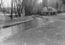
| Date: | 05 1936 |
|---|---|
| Description: | View down a fieldstone-lined stream towards a graceful stone bridge crossing the stream at the fish hatchery. A one and one half story building with a porc... |
If you didn't find the material you searched for, our Library Reference Staff can help.
Call our reference desk at 608-264-6535 or email us at: