 Filter: County of Sauk
Filter: Type of Map or Atlas
Filter: County of Sauk
Filter: Type of Map or Atlas

| Date: | 1900 |
|---|---|
| Description: | A Sanborn fire insurance map of Sauk City created in 1900. |
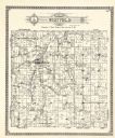
| Date: | 1922 |
|---|---|
| Description: | A plat map by Westfield created by George A. Ogle & Co. |
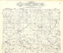
| Date: | 1922 |
|---|---|
| Description: | A plat map of the Township of Honey Creek, created by Geo. A. Ogle & Co. |

| Date: | 1922 |
|---|---|
| Description: | A plat map of the township of Delton near the Wisconsin River. |
If you didn't find the material you searched for, our Library Reference Staff can help.
Call our reference desk at 608-264-6535 or email us at: