 Filter: County of Sauk
Filter: Type of Map or Atlas
Filter: Year of 1900-1999
Filter: County of Sauk
Filter: Type of Map or Atlas
Filter: Year of 1900-1999

| Date: | 1950 |
|---|---|
| Description: | Map showing buildings formerly used as Ringling Brothers Circus winter quarters, along with adjoining buildings. |

| Date: | 1912 |
|---|---|
| Description: | This outline map of Sauk County, Wisconsin, shows the towns, cities and villages, railroads, and streams in the county. |

| Date: | 1939 |
|---|---|
| Description: | This map of Sauk County, Wisconsin, shows the township and range grid, towns, sections, cities and villages, roads, railroads, lakes and rivers, schools, a... |
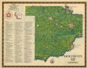
| Date: | 1975 |
|---|---|
| Description: | This 1975 map of Sauk County, Wisconsin, lists and locates historic sites and other points of interest in the county. |

| Date: | 1990 |
|---|---|
| Description: | This late 20th century tourist map of Sauk County, Wisconsin, shows the highways and roads, cities and towns, parks, airports, canoe landings, hospitals, s... |

| Date: | 1948 |
|---|---|
| Description: | This outline map of Sauk County, Wisconsin, shows the towns, cities and villages, railroads, and streams in the county. |

| Date: | 1920 |
|---|---|
| Description: | This map of Devil's Lake State Park in Sauk County, Wisconsin, shows the park limits, railroads, roads, creeks, trails, and points of interest in the area.... |

| Date: | 1923 |
|---|---|
| Description: | This topographical map of Devil's Lake State Park, Sauk County, Wisconsin, is based on 1922-1923 surveys of the area by the University of Wisconsin Summer ... |

| Date: | 1926 |
|---|---|
| Description: | Map showing Devil's Lake State Park limits, railroads, roads, creeks, trails, and park sites. Accompanying text about the location, natural features, attra... |

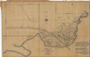
| Date: | 1915 |
|---|---|
| Description: | This 1915 map covers the section of the Wisconsin River in southern Adams, southeastern Juneau, northeastern Sauk, and northwestern Columbia counties. A po... |
| Date: | 1972 |
|---|---|
| Description: | This map shows plat of the city, city limits, local streets, and part of the Baraboo River. The map includes 3 inset maps. |

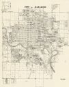
| Date: | 1975 |
|---|---|
| Description: | This map shows plat of the city, city limits, local streets, and part of Baraboo River. The map includes 2 inset maps and a legend showing residential, bus... |

| Date: | 03 1964 |
|---|---|
| Description: | This map shows lot and block numbers, some landownership, disposal plant and pumping station, streets, parks, and vacated land. Lake Delton and streets are... |
| Date: | 1932 |
|---|---|
| Description: | This blue line print plat map shows local streets, numbered blocks and lots, village limits, and land ownership by name. Also included are manuscript annot... |

| Date: | 12 1903 |
|---|---|
| Description: | This manuscript blueprint map shows streets and lots and includes certifications in the left margin. Horizontal streets top to bottom are: Iroquois, Main, ... |

| Date: | 1940 |
|---|---|
| Description: | This pictorial map shows points of interest, recreation activities, and highways in the vicinity of the restaurant and covers the Wisconsin River Valley be... |
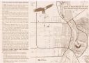
| Date: | 1999 |
|---|---|
| Description: | This map shows the best places to view bald eagles and areas to avoid when watching for eagles. The back of the map includes text and illustrations. |

| Date: | 1949 |
|---|---|
| Description: | This map shows points of interest, historic sites, buildings, trails, roads, and general animal and plant locations. |

| Date: | 1903 |
|---|---|
| Description: | This blue line print shows quartzite areas, mines, railroads, and roads. The map covers townships 11-13 north, ranges 4-8 east, in parts of Sauk and Columb... |
If you didn't find the material you searched for, our Library Reference Staff can help.
Call our reference desk at 608-264-6535 or email us at:
