Filter: County of Sauk
Filter: Community of Honey Creek
Filter: County of Sauk
Filter: Community of Honey Creek

| Community: | Honey Creek |
|---|---|
| County: | Sauk |
| Historic Name: | Durst-Bloedau Site |
| Reference Number: | 78000137 |
| Community: | Honey Creek |
|---|---|
| County: | Sauk |
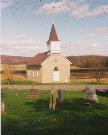
| Historic Name: | Salem Evangelical Church |
| Reference Number: | 86003576 |
| Community: | Honey Creek |
|---|---|
| County: | Sauk |
| Historic Name: | Raddatz Rockshelter |
| Reference Number: | 78000139 |
| Community: | Honey Creek |
|---|---|
| County: | Sauk |
| Historic Name: | Our Lady of Loretto Roman Catholic Church and Cemetery |
| Reference Number: | 90000378 |
| Date: | 1950 |
|---|---|
| Description: | View of the Little Prairie school with a car parked alongside it. Playground equipment is in the yard. |
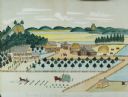
| Date: | 1875 |
|---|---|
| Description: | Seifert's watercolor is fairly large, measuring 27" wide by 21" high, and provides a detailed depiction of a nineteenth century Wisconsin farm. The small s... |
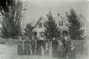
| Date: | 1898 |
|---|---|
| Description: | Group portrait of the Jacob Gasser family standing in front of the farmhouse at Tower Rock Farm. |
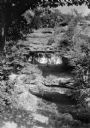
| Date: | 1925 |
|---|---|
| Description: | The Raddatz Natural Bridge and Rock Shelter, now in Natural Bridge State Park, established in 1972. |

| Wisconsin Historical Museum Object – Feature Story |
|---|
| Landscape view of the Martin Luetscher II farmstead, Honey Creek Township, Wisconsin, c. 1875 (Museum object #2005.182.1) |
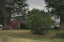
| Date: | 06 23 2012 |
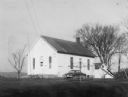
|---|---|
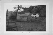
| Description: | View of the Tower Rock Farm, which is owned by the Gasser family. A large bush obscures the view of the house. |
| Date: | |
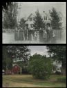
|---|---|
| Description: | A vintage view and a modern view of Tower Rock Farm, presented as a pair. The vintage view shows the Jacob Gasser family posing in front of the farmhouse. ... |
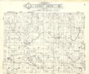
| Date: | 1922 |
|---|---|
| Description: | A plat map of the Township of Honey Creek, created by Geo. A. Ogle & Co. |
| Community: | Honey Creek |
|---|---|
| County: | Sauk |
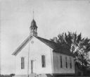
| Historic Name: | ST. MARY'S CHURCH OF HONEY CREEK |
| Reference Number: | 47732 |
| Community: | Honey Creek |
|---|---|
| County: | Sauk |
| Historic Name: | |
| Reference Number: | 91027 |

| Community: | Honey Creek |
|---|---|
| County: | Sauk |
| Historic Name: | |
| Reference Number: | 91028 |

| Community: | Honey Creek |
|---|---|
| County: | Sauk |
| Historic Name: | |
| Reference Number: | 91029 |
| Community: | Honey Creek |
|---|---|
| County: | Sauk |
| Historic Name: | |
| Reference Number: | 91030 |

| Community: | Honey Creek |
|---|---|
| County: | Sauk |
| Historic Name: | |
| Reference Number: | 91031 |

| Community: | Honey Creek |
|---|---|
| County: | Sauk |
| Historic Name: | |
| Reference Number: | 91032 |
If you didn't find the material you searched for, our Library Reference Staff can help.
Call our reference desk at 608-264-6535 or email us at: