 Filter: County of Vilas
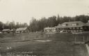
| Date: | 1905 |
|---|---|
| Description: | View across lawn towards main lodge and cabins at the Hemlock Resort on the east shore of Catfish Lake, STH 70, east of Eagle River. Caption reads: "View o... |

| Date: | 1920 |
|---|---|
| Description: | View toward a cabin among birch trees at the resort adjacent to the lake, on STH 17 south of Eagle River. Caption reads: "Indian Lake Resort, Eagle River, ... |

| Date: | 1920 |
|---|---|
| Description: | Close-up of the cottage and birch trees at the resort located east of Eagle River at 1458 E. Dollar Lake Road at the outlet of Eagle Lake. Caption reads: "... |

| Date: | 1920 |
|---|---|
| Description: | View of the dining room. The resort is on Pickerel Lake, east of STH 55 at 580 Flint Ridge Lane and south of Crandon. Caption reads: "Corner of Dining Room... |
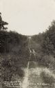
| Date: | 1905 |
|---|---|
| Description: | The two-track unpaved road to "The Morey" northeast of Eagle River, on the east side of Otter Lake. Caption reads: "The Road to 'The Morey.'" |
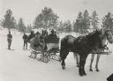
| Date: | |
|---|---|
| Description: | Winter scene with six well-bundled passengers in a sleigh pulled by two horses and pulling two skiers behind. In the background are pine trees. |
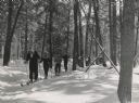
| Date: | 02 25 1940 |
|---|---|
| Description: | Winter scene with cross country skiers from Eagle River skiing on the Anvil Lake Ski Trail in the Nicolet National Forest. |

| Date: | 02 1937 |
|---|---|
| Description: | This topographical map of the forest preserve shows highways, roads, trails, telephone lines, Native American reservations, Ranger sub-stations, state nurs... |

| Date: | 1853 |
|---|---|
| Description: | This map shows camps, forts, logging camps, lakes, roads, railroads, the Wisconsin River, and Lac Du Flambeau Indian Reservation. Some points of interest a... |
| Date: | 01 1969 |
|---|---|
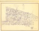
| Description: | A map of Vilas county in northern Wisconsin. |
| Date: | 1907 |
|---|---|
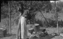
| Description: | Chippewa woman standing outdoors stirring one of three pots suspended over an open fire. |

| Date: | 1910 |
|---|---|
| Description: | This map shows shoreline lot numbers and acreages, the Wisconsin River, and the Michigan and Wisconsin state line. Manuscript annotations relating to topon... |

| Date: | 1911 |
|---|---|
| Description: | This map shows railroads, roads, swamps, a school site and farm, and a mill site. The map includes a "typical township" diagram. Lac du Flambeau, Long Lake... |

| Date: | 1935 |
|---|---|
| Description: | This map shows railroads, telephone lines, roads, trails, schools, sub-agency, lookout stations, churches, community centers, and school site and farm. Bil... |

| Date: | 1962 |
|---|---|
| Description: | This map shows roads, golf courses, ski areas, boat landings, camp sites, waysides, parks, beaches, scenic views, virgin timber tracts, airports, boys and ... |

| Date: | 2006 |
|---|---|
| Description: | This map includes indexed advertisements and map of the Lac du Flambeau region on back. The map is broken into 9 zones, each marked with state and club tra... |

| Date: | 1955 |
|---|---|
| Description: | This map shows roads, golf courses, airports, fire towers, schools, camp grounds, rivers, streams, lakes, and railroads. The right margin of the map includ... |

| Date: | 1930 |
|---|---|
| Description: | This map shows roads and lakes and includes an inset illustration of Manitowish Waters Fish Hatchery. The back of the map includes a resorts directory, tex... |

| Date: | 1975 |
|---|---|
| Description: | This map shows nature trails, public attractions, public hunting and fishing grounds, dams, waysides, lakes, highways, and roads. The upper right corner in... |

| Date: | 1994 |
|---|---|
| Description: | This map shows historical sites, picnic grounds, public boat landings, canoe and motor boat trips, and resort locations. The left margin of the map include... |
If you didn't find the material you searched for, our Library Reference Staff can help.
Call our reference desk at 608-264-6535 or email us at: