 Filter: FORMAT_DIMENSIONS of 7.5 x 7.5 inches
Filter: County of Dane
Filter: FORMAT_DIMENSIONS of 7.5 x 7.5 inches
Filter: County of Dane

| Date: | 1861 |
|---|---|
| Description: | Dane County plat map of the town of Windsor. |
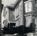
| Date: | 1940 |
|---|---|
| Description: | Deutsches Haus, formerly the Dudley house. |
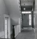
| Date: | 1951 |
|---|---|
| Description: | Interior of the back hall of a house at 524 North Henry Street. |
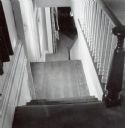
| Date: | 1951 |
|---|---|
| Description: | Interior view of the house at 524 North Henry Street, showing the first floor stairway down to the lower level. |
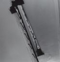
| Date: | 1951 |
|---|---|
| Description: | An interior view of a house at 524 North Henry Street, looking at the second floor through a stairwell. |
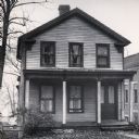
| Date: | 1948 |
|---|---|
| Description: | The Samuel & Caroline Klauber home at 115 West Wilson Street. |
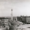
| Date: | |
|---|---|
| Description: | Elevated view from the Wisconsin State Capitol looking east, towards the old Water Works tower on East Washington Avenue. |
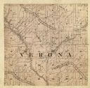
| Date: | 1861 |
|---|---|
| Description: | A map of the Verona Township, which is a section of a larger Dane County map. |
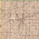
| Date: | 1914 |
|---|---|
| Description: | The Verona township, a detail of the Dane County, Wisconsin map of land ownership. |

| Date: | 1861 |
|---|---|
| Description: | The township of Primrose, which is a detail from the plat map of Dane County. |

| Date: | 1861 |
|---|---|
| Description: | The township of Montrose, which is a detail from a Dane County plat map. |
If you didn't find the material you searched for, our Library Reference Staff can help.
Call our reference desk at 608-264-6535 or email us at:

