 Filter: Subject of aerial photographs
Filter: Subject of housing
Filter: Subject of aerial photographs
Filter: Subject of housing

| Date: | 06 07 1954 |
|---|---|
| Description: | Aerial view of the Midvale neighborhood under construction showing the intersection of Midvale and Tokay Boulevards near the southwestern city limits of Ma... |

| Date: | 1945 |
|---|---|
| Description: | View of the lower campus of the University of Wisconsin-Madison includes Bascom Hill, Wisconsin Historical Society, Memorial Union and the Armory (Red Gym ... |
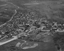
| Date: | 1900 |
|---|---|
| Description: | Aerial view of town, with houses in foreground, and hills on the horizon in the background. Caption reads: "Baraboo, Wis." |
| Date: | 1957 |
|---|---|
| Description: | Aerial view including many buildings and a baseball diamond. |

| Date: | 1922 |
|---|---|
| Description: | Aerial view of the Wisconsin State Capitol and Lake Monona. |
| Date: | 1957 |
|---|---|
| Description: | Aerial view of town including houses, water tower, city streets and buildings. |

| Date: | 1947 |
|---|---|
| Description: | Aerial view of one hundred ninety government surplus trailers, parked near Camp Randall, provided temporary housing for World War II veterans and their fam... |
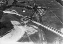
| Date: | |
|---|---|
| Description: | Aerial view of Dell View Hotel and Lake Delton airport. |
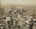
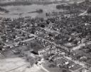
| Date: | 1930 |
|---|---|
| Description: | Aerial view of downtown area including churches, homes, and large buildings, stretching to the horizon. |
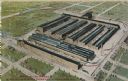
| Date: | 1910 |
|---|---|
| Description: | Aerial view of the factory surrounded by fields, roads, and several houses, as well as the railroad tracks that go around the building. Caption reads: "Wes... |

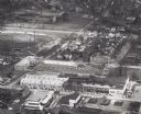
| Date: | 03 06 1948 |
|---|---|
| Description: | Aerial view of High School, in the upper half of the image, with fields, trees, and roadways surrounding it. In the lower half is a residential neighborho... |

| Date: | 1964 |
|---|---|
| Description: | Marshfield Airways, covered with snow. A river full of ice and snow, with boats along the shoreline, is in the lower portion of the image. |
| Date: | 1961 |
|---|---|
| Description: | Aerial view of the Miller Electic Manufacturing Co. and surrounding area. |
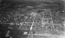
| Date: | 1939 |
|---|---|
| Description: | Elevated winter scene of Greendale (Milwaukee Co.), Wisconsin. Housing, roads and trees are visible in the distance. One person is walking through the snow... |
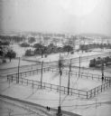
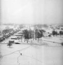
| Date: | 1939 |
|---|---|
| Description: | Elevated view of village with snow on the ground. A tennis court, flag pole, and pedestrians are visible in the foreground. Behind the tennis court are roa... |
| Date: | 1935 |
|---|---|
| Description: | Aerial view, taken from an airplane, overlooking the streets, houses, stores, trees and railroad cars. |

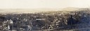
| Date: | |
|---|---|
| Description: | Sepia-toned elevated panorama, built from four separate photographs, of Sauk City. The Wisconsin River is in the background, with large hills on the other ... |
If you didn't find the material you searched for, our Library Reference Staff can help.
Call our reference desk at 608-264-6535 or email us at: