 Filter: Subject of airports
Filter: Subject of water
Filter: Subject of airports
Filter: Subject of water

| Date: | 1923 |
|---|---|
| Description: | Map of Oneida County-Rhinelander Airport which was laid out at the county fairgrounds. The map appears on the reverse side of a letter Roy Larson received ... |

| Date: | 08 02 2001 |
|---|---|
| Description: | A rainy day at Middleton Municipal Airport, formerly the Morey Airfield. |

| Date: | 11 16 2001 |
|---|---|
| Description: | Aerial view of General Mitchell International in Milwaukee, looking southeast to the Lake Michigan shoreline. |
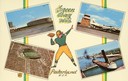
| Date: | 1957 |
|---|---|
| Description: | Composite image of "Packerland U.S.A." including prominent attractions: Lambeau Field, home of the Green Bay Packers, NFL Football team; the Brown County A... |
| Date: | |
|---|---|
| Description: | Aerial view of Pennco Field (Royal Airport), the shoreline of Lake Monona, and the surrounding countryside near the city limits. |

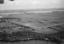
| Date: | 1930 |
|---|---|
| Description: | Aerial view of the Pennco Field (Royal Airport), including the hanger and airplanes on the ground. Lake Monona, the Wisconsin State Capitol, and the Madiso... |

| Date: | |
|---|---|
| Description: | Aerial view of a crowd at the Pennco Field (Royal Airport), gathered for an aerial show. Biplanes possibly used for the show are on the airstrip. Automob... |

| Date: | 1930 |
|---|---|
| Description: | Aerial view of biplanes at the Pennco Field (Royal Airport), probably for an air show. Lake Monona is in the background. |

| Date: | 1950 |
|---|---|
| Description: | A map from the Wisconsin identifying the locations airports and other landing facilities in the state. On the opposite side the map includes an alphabetica... |

| Date: | 1939 |
|---|---|
| Description: | This nine-part map from the U.S. Bureau of Public Roads identifies federal and state highways in Wisconsin by pavement type. County, forest, park, and publ... |

| Date: | 1944 |
|---|---|
| Description: | This nine-part map from the U.S. Bureau of Public Roads identifies federal and state highways in Wisconsin by pavement type. County, forest, park, and publ... |

| Date: | 1969 |
|---|---|
| Description: | This Post Office Department map identifies post offices, summer post offices, rural stations, highway post offices, Post Office sectional centers, rural de... |

| Date: | 1946 |
|---|---|
| Description: | A map showing the roads, railroads, towns, cities and villages, streams and lakes, airports, schools, churches, cemeteries, and golf courses in Kenosha Cou... |

| Date: | 02 1956 |
|---|---|
| Description: | This 1956 map of Waukesha County, Wisconsin, shows the township and range grid, towns, sections, cities and villages, roads, railroads, dams, airports, par... |

| Date: | 1987 |
|---|---|
| Description: | This 1987 map of Racine and Kenosha counties, Wisconsin, shows towns, sections, cities and villages, zip code boundaries, highways and roads, bicycle route... |

| Date: | 1970 |
|---|---|
| Description: | Color coded map. Legend in the top left hand corner reads: "EXISTING AIRPORT PAVEMENT" (purple), "FUTURE 5-YEAR DEVELOPMENT" (bright pink), "ULTIMATE AIRPO... |

| Date: | 1900 |
|---|---|
| Description: | This map of Three Lakes shows forest fire lookout towers, picnic grounds, an airport, roads, and railroad. The map features text boxes on the Village of Th... |

| Date: | 1970 |
|---|---|
| Description: | This map is intended for tourists of La Crosse. The cover features images of farms and natural land and reads: "friends are but strangers... we have yet to... |

| Date: | 1975 |
|---|---|
| Description: | This standard U.S.G.S. topographic map was annotated by civil engineer and railroad historian James P. Kaysen to show the location of existing and defunct ... |

| Date: | 1929 |
|---|---|
| Description: | This is a blue line print map that shows local streets, railroads, local businesses, schools, parks, cemeteries, the airport, the state capitol, the Univer... |
If you didn't find the material you searched for, our Library Reference Staff can help.
Call our reference desk at 608-264-6535 or email us at: