 Filter: Subject of alleys
Filter: Subject of land
Filter: Subject of alleys
Filter: Subject of land
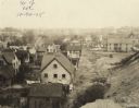
| Date: | 10 30 1925 |
|---|---|
| Description: | Elevated view of alley between houses in a neighborhood from railroad embankment. An elevated bridge is just visible in the far background. Text at foot of... |

| Date: | 1861 |
|---|---|
| Description: | This map shows lot and block numbers, piers, streets, monuments, and township section corners. Included is a note on the width of avenues, piers, slips, al... |
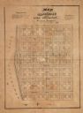
| Date: | |
|---|---|
| Description: | This plat map shows numbered blocks and lots, local streets, and part of Lake Apuckaway. The map also includes references for dimensions of lots, streets, ... |

| Date: | 1977 |
|---|---|
| Description: | View down hill towards a man washing his car in the alley of a neighborhood. Rooftops are in the background. |
If you didn't find the material you searched for, our Library Reference Staff can help.
Call our reference desk at 608-264-6535 or email us at: