 Filter: Subject of alleys
Filter: Subject of railroads
Filter: Subject of alleys
Filter: Subject of railroads

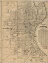
| Date: | 1861 |
|---|---|
| Description: | This map shows lot and block numbers, piers, streets, monuments, and township section corners. Included is a note on the width of avenues, piers, slips, al... |
| Date: | 1916 |
|---|---|
| Description: | This map shows wards, roads, railroads, parks, cemeteries, select buildings, and Lake Michigan. Also included is a street index and manuscript annotations ... |
If you didn't find the material you searched for, our Library Reference Staff can help.
Call our reference desk at 608-264-6535 or email us at: