 Filter: Subject of automobile driving
Filter: Type of Map or Atlas
Filter: Subject of land
Filter: Subject of automobile driving
Filter: Type of Map or Atlas
Filter: Subject of land

| Date: | 1930 |
|---|---|
| Description: | Pictorial map of Glacier National Park, Montana and Waterton Lakes National Park, Alberta. Illustrated by Joe Scheurle, it depicts white people, American ... |

| Date: | 1910 |
|---|---|
| Description: | This is a 5 part map showing automobile roads, common roads, cross roads, and railroads. Each map includes a diagram on reverse side and automobile trips o... |
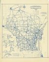
| Date: | 1937 |
|---|---|
| Description: | This blue line print map shows highways, the scale of traffic volume, and average 24 hour traffic. Also included are inset maps of Green Bay, Oshkosh, Fond... |
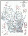
| Date: | 1998 |
|---|---|
| Description: | This map shows the annual average of daily traffic for 1997. Includes insets of Milwaukee County; Eau Claire and vicinity; Green Bay and vicinity; Appleton... |

| Date: | 1962 |
|---|---|
| Description: | This colored map represents "Tour #1" of a series of driving tours of the state published by the Sperry & Hutchinson Company, in order to "help you enjoy W... |
If you didn't find the material you searched for, our Library Reference Staff can help.
Call our reference desk at 608-264-6535 or email us at: