Filter: Subject of automobile driving
Filter: Subject of cities and towns
Filter: Subject of land
Filter: Subject of automobile driving
Filter: Subject of cities and towns
Filter: Subject of land

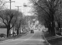
| Date: | 10 09 1928 |
|---|---|
| Description: | View of the Wisconsin State Capitol from the center of East Washington Avenue, looking through two trees planted on a wide grassy median. |
| Date: | 1958 |
|---|---|
| Description: | Intersection of Park and State Streets from the Wisconsin Historical Society. The sign for the Wisconsin Historical Society is on the lawn in the center, a... |
| Date: | 1904 |
|---|---|
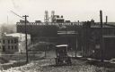
| Description: | A car climbs up a dirt and gravel road in an industrial area. The Milwaukee-Western Fuel Co. building is in the background, as well as a building with a si... |
| Date: | |
|---|---|
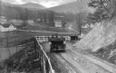
| Description: | Elevated view of two cars on a dirt road heading downhill. A town is in the valley below, and mountains are in the distance. |

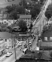
| Date: | 1925 |
|---|---|
| Description: | View of a city featuring a downtown district and a neighborhood built into the hillside. |

| Date: | 1925 |
|---|---|
| Description: | View of a church, field, and cemetery from a hilltop. A car drives down the road in the lower-right corner. |
| Date: | 1922 |
|---|---|
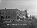
| Description: | View across street of children on the sidewalk outside the Coon Valley State Bank. At the end of the street, there is an automotive repair station. |
| Date: | 1929 |
|---|---|
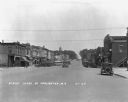
| Description: | View down a commercial street, with an automobile coming down the street. There is a soda/ice cream shop which offers tobacco, cigars, and candy. The City ... |
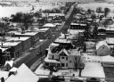
| Date: | 1929 |
|---|---|
| Description: | View down Main Street. Cars and shops line the street. The Soldiers and Sailors of the Civil War memorial is in the far background at the top of the hill. |
| Date: | 1948 |
|---|---|
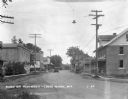
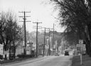
| Description: | "Main (Milwaukee) Street. At this time Hwy 41 was still routed through the village." |

| Date: | 1910 |
|---|---|
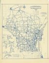
| Description: | This is a 5 part map showing automobile roads, common roads, cross roads, and railroads. Each map includes a diagram on reverse side and automobile trips o... |

| Date: | 1910 |
|---|---|
| Description: | Residential street in winter, with a Model T Ford driving uphill. |
| Date: | 1937 |
|---|---|
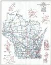
| Description: | This blue line print map shows highways, the scale of traffic volume, and average 24 hour traffic. Also included are inset maps of Green Bay, Oshkosh, Fond... |
| Date: | 1998 |
|---|---|
| Description: | This map shows the annual average of daily traffic for 1997. Includes insets of Milwaukee County; Eau Claire and vicinity; Green Bay and vicinity; Appleton... |
If you didn't find the material you searched for, our Library Reference Staff can help.
Call our reference desk at 608-264-6535 or email us at: