Filter: Subject of automobile driving
Filter: Subject of cities and towns
Filter: Subject of automobile driving
Filter: Subject of cities and towns

| Date: | 1923 |
|---|---|
| Description: | This map shows trails, some in red, for automobiles. The right margin includes a key of markings as well as Minnesota and Wisconsin Highway signs. Communit... |
| Date: | 1926 |
|---|---|
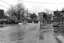
| Description: | View down middle of street. Two cars are passing each other, and commercial buildings are on both sides of the street. |
| Date: | 1928 |
|---|---|
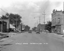
| Description: | View down a commercial street. An automotive repair shop is located on the left side of the street. |
| Date: | 05 28 1956 |
|---|---|
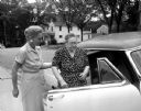
| Description: | Transportation is often a problem for the older population. The Council of Jewish Women has arranged a transportation group to take older Jewish persons to... |

| Date: | 06 18 1956 |
|---|---|
| Description: | Twelve men are posing in front of over twenty similar automobiles parked in two neat lines on pavement in back of East High School. The men are auto dealer... |

| Date: | 1920 |
|---|---|
| Description: | This early road map shows the system of roads in Wisconsin, northern Illinois, northeastern Iowa, southeastern Minnesota, and the western portion of Michig... |

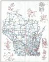
| Date: | 1923 |
|---|---|
| Description: | This early road map shows the system of roads in Wisconsin, northern Illinois, northeastern Iowa, southeastern Minnesota, and the western portion of Michig... |
| Date: | 1924 |
|---|---|
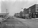
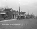
| Description: | View across railroad tracks of storefronts located near the train depot. The shops include: Montford Lumber Company, Damerow's Cafe, and the American Hotel... |

| Date: | 1926 |
|---|---|
| Description: | View down Main Street. Shops and parked cars line the street. On the near left, there is a billboard for Granger rough cut tobacco, and there is a barbers... |

| Date: | 1910 |
|---|---|
| Description: | This is a 5 part map showing automobile roads, common roads, cross roads, and railroads. Each map includes a diagram on reverse side and automobile trips o... |

| Date: | 06 17 1957 |
|---|---|
| Description: | John McDowell (left), supervisor of summer program for Madison public schools, and Milo Swanton, a member of the AAA advisory committee, stand in front of ... |

| Date: | 05 02 1958 |
|---|---|
| Description: | Winston Smith and his son, Wade, sit in their restored 1909 Cadillac automobile before the "You Auto Buy Now" parade. |
| Date: | 1930 |
|---|---|
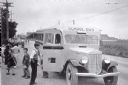
| Description: | View down side of road of a group of children exiting an International school bus. On the front and side of the bus is painted the "International" emblem. ... |
| Date: | 1941 |
|---|---|
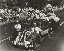
| Description: | Slightly elevated view of celebrants at an American Legion convention parade riding on a float made to represent Wisconsin fishing. |

| Date: | 1910 |
|---|---|
| Description: | Residential street in winter, with a Model T Ford driving uphill. |

| Date: | 1961 |
|---|---|
| Description: | View from front of woman driving a yellow Scout with white topper. There is a young boy in the passenger seat. A grill and tow hook are attached to the fro... |
| Date: | 1937 |
|---|---|
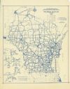
| Description: | This blue line print map shows highways, the scale of traffic volume, and average 24 hour traffic. Also included are inset maps of Green Bay, Oshkosh, Fond... |
| Date: | 1998 |
|---|---|
| Description: | This map shows the annual average of daily traffic for 1997. Includes insets of Milwaukee County; Eau Claire and vicinity; Green Bay and vicinity; Appleton... |
If you didn't find the material you searched for, our Library Reference Staff can help.
Call our reference desk at 608-264-6535 or email us at: