 Filter: Subject of automobile driving
Filter: Subject of economics
Filter: Creator Name of Unknown
Filter: Subject of automobile driving
Filter: Subject of economics
Filter: Creator Name of Unknown
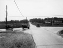
| Date: | 1918 |
|---|---|
| Description: | The intersection of Port Washington Road and Silver Spring Drive near Milwaukee. Even if one did not know that this was the intersection of a major north-s... |
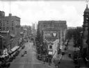
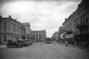
| Date: | 1930 |
|---|---|
| Description: | Elevated view of the junction of Congress and First Streets downtown, featuring cars, pedestrians, storefronts, and railroad tracks. |

| Date: | |
|---|---|
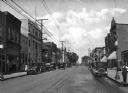
| Description: | View down Main Street. Cars are parked on either side of the street, and two cars are being driven by storefronts. On the left stands the Citizens National... |

| Date: | |
|---|---|
| Description: | View down Main Street. Cars are parked on either side of the street and two cars are being driven by storefronts. Citizens National Bank, built in 1893, st... |
| Date: | |
|---|---|
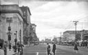
| Description: | Automobiles drive past storefronts and can be seen parked on either side of Grand Avenue. Pedestrians walk on the sidewalk near the Citizens National Bank ... |
| Date: | |
|---|---|
| Description: | View down Main Avenue, a downtown business district. On the left corner of the avenue stands the Service Trust Company, built in 1925. Men and women cross ... |
| Date: | |
|---|---|
| Description: | View of Flores Avenue, a commercial section of downtown. The city hall, built in 1884, stands on the left near Laredo National Bank, founded in 1892. On ... |

| Date: | 1915 |
|---|---|
| Description: | View down a street in a business district. A statue has a sign that reads: "If you can't fight, your dollars can," stands near an intersection. The First N... |
| Date: | |
|---|---|
| Description: | Letterhead of the Wm. Ewig Company, an insurance company in Milwaukee, Wisconsin, with full-color depictions of a scene with three traffic accidents involv... |

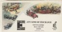
| Date: | 1920 |
|---|---|
| Description: | A two-sided map of the state of Wisconsin. The front includes towns and major cities as well as state and county trunk highways. The back includes a smalle... |
If you didn't find the material you searched for, our Library Reference Staff can help.
Call our reference desk at 608-264-6535 or email us at: