 Filter: Subject of automobile driving
Filter: Subject of hotels
Filter: Subject of restaurants
Filter: Subject of automobile driving
Filter: Subject of hotels
Filter: Subject of restaurants
| Date: | 1923 |
|---|---|
| Description: | View down retail street. The shops include a clothing store, Barig and Son Undertakers, a hotel, and drugstore. Cars are parked in the middle of the street... |

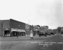
| Date: | 1924 |
|---|---|
| Description: | A view down a street with stores and shops. The stores include: Koffee Kup Kafe, Hotel East, Boortz Garage, a hardware store, and the State & County Deposi... |
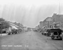
| Date: | 1929 |
|---|---|
| Description: | A busy commercial area. Cars are parked diagonally on either side of the street. There is a Chevrolet repair shop, gas station, hotel, Ford repair shop, an... |
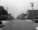
| Date: | 1924 |
|---|---|
| Description: | View down commercial street. The shops are: Crandon Baking Company, a drugstore, the Hotel Hellstrom and Livery, a restaurant, First National Bank, a baker... |

| Date: | 1920 |
|---|---|
| Description: | This early road map shows the system of roads in Wisconsin, northern Illinois, northeastern Iowa, southeastern Minnesota, and the western portion of Michig... |
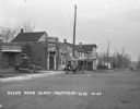
| Date: | 1924 |
|---|---|
| Description: | View across railroad tracks of storefronts located near the train depot. The shops include: Montford Lumber Company, Damerow's Cafe, and the American Hotel... |

| Date: | 1935 |
|---|---|
| Description: | This road map shows automobile routes across the state of Wisconsin. Advertisements for various hotels are featured along the bottom edge of the map, while... |
If you didn't find the material you searched for, our Library Reference Staff can help.
Call our reference desk at 608-264-6535 or email us at: