 Filter: Subject of automobile driving
Filter: Subject of recreation areas
Filter: Subject of automobile driving
Filter: Subject of recreation areas
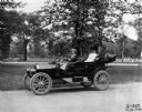
| Date: | 07 14 1910 |
|---|---|
| Description: | Woman and two passengers driving an International J-30 passenger car with its top down through a city park. Also known as the IHC 30, the J-30 was produced... |
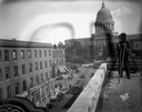
| Date: | 09 27 1930 |
|---|---|
| Description: | The corner of State Street and Capitol Square from the roof of the Leath Furniture Store, with a view of the 100 block of State Street, the Wisconsin State... |

| Date: | 1905 |
|---|---|
| Description: | South Entrance; in the background is a lighthouse. In the center is a bridge flanked by carved stone lions. A man on a motor car is crossing the bridge. |

| Date: | 07 14 1910 |
|---|---|
| Description: | Man driving two women in an International J-30 automobile. In the background is a park or cemetery. |

| Date: | 1930 |
|---|---|
| Description: | Pictorial map of Glacier National Park, Montana and Waterton Lakes National Park, Alberta. Illustrated by Joe Scheurle, it depicts white people, American ... |

| Date: | |
|---|---|
| Description: | View down 52nd Street, a road leading into Fairmount Park. An automobile and a pedestrian pass by rows of trees. |
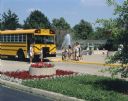
| Date: | 1990 |
|---|---|
| Description: | Group of Brownie Girl Scouts and their leader are posing next to an International school bus at the Louisville zoo. In the background zookeepers and childr... |

| Date: | |
|---|---|
| Description: | A person is driving a red Scout on a road in a park or recreation area. There is a park building in the background on the right, and a picnic table is near... |

| Date: | 1968 |
|---|---|
| Description: | Elevated view of 946 vehicles lined up at the Clark County fairgrounds awaiting their drivers for the largest drive-away ever held by International Harvest... |

| Date: | 1933 |
|---|---|
| Description: | This road map shows automobile routes across Wisconsin as well as portions of Illinois, Minnesota, Iowa and Michigan. Lakes Michigan, Superior and Winnebag... |

| Date: | 1935 |
|---|---|
| Description: | This colored road map comes with a map legend and explanation, as well as an index of cities and towns (and their populations) in Wisconsin. Information ab... |

| Date: | 1966 |
|---|---|
| Description: | This colored road map shows automobile roads in Wisconsin as well as portions of nearby states. Information on the quality and type of any road shown (inte... |

| Date: | 1966 |
|---|---|
| Description: | This colored road map shows automobile roads in Wisconsin as well as portions of nearby states. A map key indicates relative sizes of cities and towns. On ... |

| Date: | 1970 |
|---|---|
| Description: | This colored map displays a brief description of tourist attractions in the state, as well as a grid of state parks and recreational facilities. There is a... |

| Date: | 1966 |
|---|---|
| Description: | This colored road map shows automobile roads in Wisconsin as well as portions of nearby states. Information on the quality and type of any road shown (inte... |

| Date: | 1972 |
|---|---|
| Description: | This colored map displays Wisconsin and bordering areas of Iowa, Minnesota, and Michigan. There is color-coding on the map to indicate National Forests, an... |

| Date: | 1970 |
|---|---|
| Description: | This colored map displays detailed maps of Green Bay, Appleton, Racine, Milwaukee, Kenosha, and Duluth-Superior. At the top right is a map location list of... |

| Date: | 1971 |
|---|---|
| Description: | This colored map displays Wisconsin and bordering areas of Iowa, Minnesota, and Michigan. There is color-coding on the map to indicate National Forests, an... |

| Date: | 1973 |
|---|---|
| Description: | This colored map displays Wisconsin and bordering areas of Iowa, Minnesota, and Michigan. There is color-coding on the map to indicate National Forests, a... |

| Date: | 1975 |
|---|---|
| Description: | This colored road map of Wisconsin displays "Featured Points of Interest" and "Historical Points of Interest" in the state, including three color photograp... |
If you didn't find the material you searched for, our Library Reference Staff can help.
Call our reference desk at 608-264-6535 or email us at: