 Filter: Subject of automobile driving
Filter: Subject of restaurants
Filter: Subject of roads
Filter: Subject of automobile driving
Filter: Subject of restaurants
Filter: Subject of roads

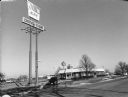
| Date: | |
|---|---|
| Description: | A sign prominently displays "OPEN THANKSGIVING DAI" in the top left corner of the frame. Across Third Street behind the sign is the 88 Tavern. Down Portlan... |
| Date: | 11 24 2000 |
|---|---|
| Description: | "On this Friday we are at Kentucky Fried Chicken in Fond du Lac, WI." |
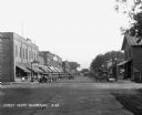
| Date: | 1929 |
|---|---|
| Description: | View down retail street. Cars are parked along the curbs. The stores include: Victrola's dealer, a cafe, a recreation parlor, a restaurant, a clothing stor... |

| Date: | 1920 |
|---|---|
| Description: | A two-sided map of the state of Wisconsin. The front includes towns and major cities as well as state and county trunk highways. The back includes a smalle... |

| Date: | 1920 |
|---|---|
| Description: | This early road map shows the system of roads in Wisconsin, northern Illinois, northeastern Iowa, southeastern Minnesota, and the western portion of Michig... |

| Date: | 1935 |
|---|---|
| Description: | This road map shows automobile routes across the state of Wisconsin. Advertisements for various hotels are featured along the bottom edge of the map, while... |

| Date: | 1976 |
|---|---|
| Description: | This colored map displays Wisconsin and portions of bordering states, including a detailed map of the Wisconsin Dells area. Surrounding the map are multipl... |

| Date: | 1977 |
|---|---|
| Description: | This colored map displays Wisconsin and portions of bordering states, including a detailed map of the Wisconsin Dells area. Surrounding the map are multipl... |
If you didn't find the material you searched for, our Library Reference Staff can help.
Call our reference desk at 608-264-6535 or email us at: