 Filter: Subject of automobile driving
Filter: Subject of roads
Filter: Subject of recreation
Filter: Subject of automobile driving
Filter: Subject of roads
Filter: Subject of recreation
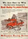
| Date: | 1923 |
|---|---|
| Description: | Advertising poster for McCormick-Deering service featuring a color illustration of a "Red Baby" farm truck. The company offered a $1,000 prize to the deale... |
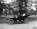
| Date: | 07 14 1910 |
|---|---|
| Description: | Woman and two passengers driving an International J-30 passenger car with its top down through a city park. Also known as the IHC 30, the J-30 was produced... |
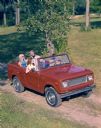
| Date: | |
|---|---|
| Description: | Color advertising photograph of two men and two younger women riding along a rural road in an International Scout convertible pickup. |
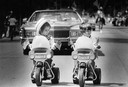
| Date: | 05 28 1979 |
|---|---|
| Description: | A pair of boy and girl toddlers lead a part of the 33rd annual Memorial Day Parade on flag-bedecked tricycles. |
| Date: | |
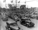
|---|---|
| Description: | Elevated view of four lanes of cars arriving at the Wisconsin State Fair's Main Gate. They are being directed by parking lot attendants. |
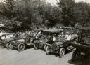
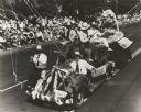
| Date: | 1913 |
|---|---|
| Description: | A slightly elevated view of a parade? of cars driving down a street as onlookers are standing by. |
| Date: | |
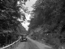
|---|---|
| Description: | A view of a car on a dirt road driving toward Mt. Tom Camp, with a wooden guardrail on one side and a natural rock formation on the other side. |
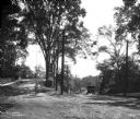
| Date: | |
|---|---|
| Description: | View toward a boy with his bicycle at the entrance to Putnam Hill Park on the left. There are telephone poles and trees in the center, street railroad trac... |
| Date: | 1941 |
|---|---|
| Description: | Slightly elevated view of celebrants at an American Legion convention parade riding on a float made to represent Wisconsin fishing. |

| Date: | 1935 |
|---|---|
| Description: | This colored road map comes with a map legend and explanation, as well as an index of cities and towns (and their populations) in Wisconsin. Information ab... |

| Date: | 1966 |
|---|---|
| Description: | This colored road map shows automobile roads in Wisconsin as well as portions of nearby states. A map key indicates relative sizes of cities and towns. On ... |

| Date: | 1966 |
|---|---|
| Description: | This colored road map shows automobile roads in Wisconsin as well as portions of nearby states. Information on the quality and type of any road shown (inte... |

| Date: | 1970 |
|---|---|
| Description: | This colored map displays detailed maps of Green Bay, Appleton, Racine, Milwaukee, Kenosha, and Duluth-Superior. At the top right is a map location list of... |

| Date: | 1971 |
|---|---|
| Description: | This colored map displays Wisconsin and bordering areas of Iowa, Minnesota, and Michigan. There is color-coding on the map to indicate National Forests, an... |

| Date: | 1973 |
|---|---|
| Description: | This colored map displays Wisconsin and bordering areas of Iowa, Minnesota, and Michigan. There is color-coding on the map to indicate National Forests, a... |

| Date: | 1975 |
|---|---|
| Description: | This colored road map of Wisconsin displays "Featured Points of Interest" and "Historical Points of Interest" in the state, including three color photograp... |

| Date: | 1976 |
|---|---|
| Description: | This colored map displays Wisconsin and portions of bordering states, including a detailed map of the Wisconsin Dells area. Surrounding the map are multipl... |

| Date: | 1977 |
|---|---|
| Description: | This colored map displays Wisconsin and portions of bordering states, including a detailed map of the Wisconsin Dells area. Surrounding the map are multipl... |
If you didn't find the material you searched for, our Library Reference Staff can help.
Call our reference desk at 608-264-6535 or email us at: