 Filter: Subject of automobile driving
Filter: Subject of roads
Filter: Subject of service industries
Filter: Subject of automobile driving
Filter: Subject of roads
Filter: Subject of service industries
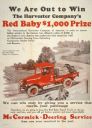
| Date: | 1923 |
|---|---|
| Description: | Advertising poster for McCormick-Deering service featuring a color illustration of a "Red Baby" farm truck. The company offered a $1,000 prize to the deale... |
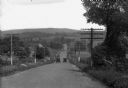
| Date: | 1912 |
|---|---|
| Description: | View down hill toward two cars passing each other along the Lincoln Highway near Bedford, Pennsylvania. The Lincoln Highway was conceived in 1912 by Carl F... |
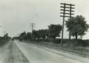
| Date: | 08 1924 |
|---|---|
| Description: | Trees and electric power lines are along a road. There are two automobiles being driven in opposite directions on Dixie Highway. |

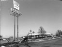
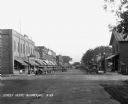
| Date: | |
|---|---|
| Description: | A sign prominently displays "OPEN THANKSGIVING DAI" in the top left corner of the frame. Across Third Street behind the sign is the 88 Tavern. Down Portlan... |
| Date: | 11 24 2000 |
|---|---|
| Description: | "On this Friday we are at Kentucky Fried Chicken in Fond du Lac, WI." |
| Date: | 1929 |
|---|---|
| Description: | View down retail street. Cars are parked along the curbs. The stores include: Victrola's dealer, a cafe, a recreation parlor, a restaurant, a clothing stor... |
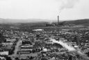
| Date: | |
|---|---|
| Description: | Elevated view of the city with a smokestack in the distance. |
| Date: | 02 03 1978 |
|---|---|
| Description: | Winter scene with mail carrier in car putting mail in a mailbox. "Ralph Koll, Rural Mail Carrier. Somewhere in this monstrous snow drift is Helen Moldenha... |

| Date: | 1920 |
|---|---|
| Description: | A two-sided map of the state of Wisconsin. The front includes towns and major cities as well as state and county trunk highways. The back includes a smalle... |
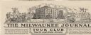
| Date: | |
|---|---|
| Description: | Letterhead of the Milwaukee Journal Tour Club, a national automobile club, with a three-quarter view of the company building surrounded by scenes of a hote... |

| Date: | 1920 |
|---|---|
| Description: | This early road map shows the system of roads in Wisconsin, northern Illinois, northeastern Iowa, southeastern Minnesota, and the western portion of Michig... |
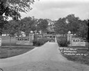
| Date: | 1927 |
|---|---|
| Description: | Front entrance to the Black Oaks resort. A man is driving an automobile down the drive near two stone walls with columns framing the entrance to the drivew... |

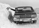
| Date: | 1972 |
|---|---|
| Description: | Man using a Scout 4x4 to plow a driveway near the side of a house. |

| Date: | 1919 |
|---|---|
| Description: | This map shows auto trails, main roads, rivers, and populations of communities. The map also shows selected hotels and garages and includes a key in the ri... |

| Date: | 1950 |
|---|---|
| Description: | Man driving an L-120 truck on a road. The open bed of the truck is piled with sacks of grain. There is a spare tire mounted on the outside of the truck bed... |

| Date: | 1927 |
|---|---|
| Description: | This map details automobile routes throughout the state as well as parts of Iowa, Minnesota, Michigan and Illinois. Cities, the Mississippi River, Lake Mic... |

| Date: | 1935 |
|---|---|
| Description: | This road map shows automobile routes across the state of Wisconsin. Advertisements for various hotels are featured along the bottom edge of the map, while... |

| Date: | 1966 |
|---|---|
| Description: | This colored road map shows automobile roads in Wisconsin as well as portions of nearby states. A map key indicates relative sizes of cities and towns. On ... |

| Date: | 1966 |
|---|---|
| Description: | This colored road map shows automobile roads in Wisconsin as well as portions of nearby states. Information on the quality and type of any road shown (inte... |

| Date: | 1970 |
|---|---|
| Description: | This colored map displays detailed maps of Green Bay, Appleton, Racine, Milwaukee, Kenosha, and Duluth-Superior. At the top right is a map location list of... |
If you didn't find the material you searched for, our Library Reference Staff can help.
Call our reference desk at 608-264-6535 or email us at: