 Filter: Subject of automobile driving
Filter: Subject of service industries
Filter: Subject of automobile driving
Filter: Subject of service industries
| Date: | |
|---|---|
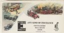
| Description: | Letterhead of the Wm. Ewig Company, an insurance company in Milwaukee, Wisconsin, with full-color depictions of a scene with three traffic accidents involv... |

| Date: | 1920 |
|---|---|
| Description: | A two-sided map of the state of Wisconsin. The front includes towns and major cities as well as state and county trunk highways. The back includes a smalle... |

| Date: | |
|---|---|
| Description: | Letterhead of the Milwaukee Journal Tour Club, a national automobile club, with a three-quarter view of the company building surrounded by scenes of a hote... |
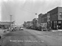
| Date: | 1928 |
|---|---|
| Description: | View down a commercial street. An automotive repair shop is located on the left side of the street. |
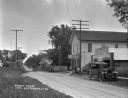
| Date: | 1926 |
|---|---|
| Description: | View from across road of an automotive repair shop along a commercial street. |

| Date: | 1920 |
|---|---|
| Description: | This early road map shows the system of roads in Wisconsin, northern Illinois, northeastern Iowa, southeastern Minnesota, and the western portion of Michig... |
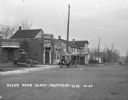
| Date: | 1924 |
|---|---|
| Description: | View across railroad tracks of storefronts located near the train depot. The shops include: Montford Lumber Company, Damerow's Cafe, and the American Hotel... |

| Date: | 1926 |
|---|---|
| Description: | View down Main Street. Shops and parked cars line the street. On the near left, there is a billboard for Granger rough cut tobacco, and there is a barbers... |
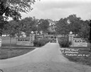
| Date: | 1927 |
|---|---|
| Description: | Front entrance to the Black Oaks resort. A man is driving an automobile down the drive near two stone walls with columns framing the entrance to the drivew... |

| Date: | 1972 |
|---|---|
| Description: | Man using a Scout 4x4 to plow a driveway near the side of a house. |

| Date: | |
|---|---|
| Description: | Two men in the cab of a red Scout pickup. They are driving on a golf course, and a green hose is visible in the back of the open pickup. |

| Date: | 1956 |
|---|---|
| Description: | Two Metros in a parking lot. On the left, a man sits in the driver's seat of a S-150 Metro with a sign painted on the side reading: "West Suburban, Grocers... |

| Date: | 1919 |
|---|---|
| Description: | This map shows auto trails, main roads, rivers, and populations of communities. The map also shows selected hotels and garages and includes a key in the ri... |

| Date: | |
|---|---|
| Description: | Lithograph of an International Harvester tractor trailer in Cuba. Advertisement also highlights Harvester service and sales locations in Cuba. At the bott... |

| Date: | 1950 |
|---|---|
| Description: | Man driving an L-120 truck on a road. The open bed of the truck is piled with sacks of grain. There is a spare tire mounted on the outside of the truck bed... |

| Date: | 1927 |
|---|---|
| Description: | This map details automobile routes throughout the state as well as parts of Iowa, Minnesota, Michigan and Illinois. Cities, the Mississippi River, Lake Mic... |

| Date: | 04 29 1979 |
|---|---|
| Description: | A man is walking through a flooded Dairy Queen parking lot in the downtown area, while cars are driving down the street. The sign in the window of the Dair... |

| Date: | 1935 |
|---|---|
| Description: | This road map shows automobile routes across the state of Wisconsin. Advertisements for various hotels are featured along the bottom edge of the map, while... |

| Date: | 1966 |
|---|---|
| Description: | This colored road map shows automobile roads in Wisconsin as well as portions of nearby states. A map key indicates relative sizes of cities and towns. On ... |

| Date: | 1967 |
|---|---|
| Description: | This colored map published by the State Historical Society of Wisconsin shows key points of interest telling the story of Wisconsin's earliest settlement a... |
If you didn't find the material you searched for, our Library Reference Staff can help.
Call our reference desk at 608-264-6535 or email us at: