Filter: Subject of automobile driving
Filter: Subject of signs and signboards
Filter: Subject of automobile driving
Filter: Subject of signs and signboards
| Date: | |
|---|---|
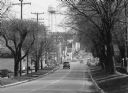
| Description: | View down a commercial main street lined with trees and parked cars. |
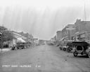
| Date: | 1929 |
|---|---|
| Description: | A busy commercial area. Cars are parked diagonally on either side of the street. There is a Chevrolet repair shop, gas station, hotel, Ford repair shop, an... |
| Date: | |
|---|---|
| Description: | View down a city street, lined with storefronts. Piggly Wiggly is visible at right; it was founded in 1916. |
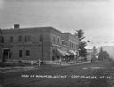
| Date: | 1922 |
|---|---|
| Description: | View across street of children on the sidewalk outside the Coon Valley State Bank. At the end of the street, there is an automotive repair station. |
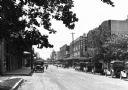
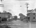
| Date: | 1924 |
|---|---|
| Description: | View down commercial street. The shops are: Crandon Baking Company, a drugstore, the Hotel Hellstrom and Livery, a restaurant, First National Bank, a baker... |
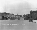
| Date: | 1929 |
|---|---|
| Description: | View down a commercial street, with an automobile coming down the street. There is a soda/ice cream shop which offers tobacco, cigars, and candy. The City ... |
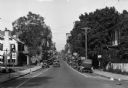
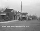
| Date: | 1929 |
|---|---|
| Description: | View down Main Street. Cars and shops line the street. The Soldiers and Sailors of the Civil War memorial is in the far background at the top of the hill. |
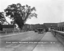
| Date: | 1929 |
|---|---|
| Description: | View across the bridge on Main Street. There are two cars and a woman and child walking across the bridge. A Chevrolet dealership is on the right. |
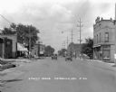
| Date: | 1948 |
|---|---|
| Description: | "Main (Milwaukee) Street. At this time Hwy 41 was still routed through the village." |
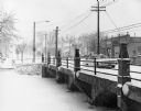
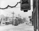
| Date: | 12 1968 |
|---|---|
| Description: | Winter scene of a snowstorm in downtown Theresa. A car drives over a bridge. Mobil gas station in the background. |
| Date: | 1926 |
|---|---|
| Description: | View down middle of street. Two cars are passing each other, and commercial buildings are on both sides of the street. |
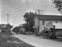
| Date: | 1926 |
|---|---|
| Description: | View from across road of an automotive repair shop along a commercial street. |

| Date: | 1920 |
|---|---|
| Description: | This early road map shows the system of roads in Wisconsin, northern Illinois, northeastern Iowa, southeastern Minnesota, and the western portion of Michig... |

| Date: | 1923 |
|---|---|
| Description: | This early road map shows the system of roads in Wisconsin, northern Illinois, northeastern Iowa, southeastern Minnesota, and the western portion of Michig... |
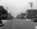
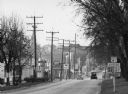
| Date: | 1924 |
|---|---|
| Description: | View across railroad tracks of storefronts located near the train depot. The shops include: Montford Lumber Company, Damerow's Cafe, and the American Hotel... |

| Date: | 1926 |
|---|---|
| Description: | View down Main Street. Shops and parked cars line the street. On the near left, there is a billboard for Granger rough cut tobacco, and there is a barbers... |
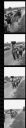
| Date: | 1966 |
|---|---|
| Description: | A series of images from a contact sheet containing scenes of Obreros Unidos (United Workers) leaving Wautoma and marching towards Madison along Highway 21 ... |
If you didn't find the material you searched for, our Library Reference Staff can help.
Call our reference desk at 608-264-6535 or email us at: