 Filter: Subject of automobile driving
Filter: Subject of traffic signs and signals
Filter: Subject of signs and signboards
Filter: Subject of automobile driving
Filter: Subject of traffic signs and signals
Filter: Subject of signs and signboards
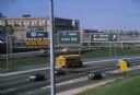
| Date: | 1981 |
|---|---|
| Description: | Fond du Lac Avenue (State Highway 145) exit from Interstate I-43 in Milwaukee. As originally conceived, the interstate system in Wisconsin was to consist ... |
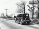
| Date: | 04 23 1926 |
|---|---|
| Description: | A man stops his automobile at a railroad crossing while waiting for the train to cross a paved road. The traffic sign to the right of the car reads: "Railr... |
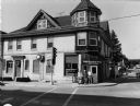
| Date: | 06 08 2001 |
|---|---|
| Description: | "The Slinger House is at 100 W. Washington St. in Slinger, WI, at the intersection of Highway's 175 & 144." |

| Date: | 1920 |
|---|---|
| Description: | This early road map shows the system of roads in Wisconsin, northern Illinois, northeastern Iowa, southeastern Minnesota, and the western portion of Michig... |

| Date: | 1923 |
|---|---|
| Description: | This early road map shows the system of roads in Wisconsin, northern Illinois, northeastern Iowa, southeastern Minnesota, and the western portion of Michig... |

| Date: | |
|---|---|
| Description: | View across East Washington Avenue towards the Gisholt factory at the intersection of Baldwin Street. There is an enclosed skybridge (called an "overhead" ... |
If you didn't find the material you searched for, our Library Reference Staff can help.
Call our reference desk at 608-264-6535 or email us at: