 Filter: Subject of automobile driving
Filter: Subject of traffic signs and signals
Filter: Subject of automobile driving
Filter: Subject of traffic signs and signals
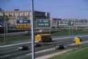
| Date: | 1981 |
|---|---|
| Description: | Fond du Lac Avenue (State Highway 145) exit from Interstate I-43 in Milwaukee. As originally conceived, the interstate system in Wisconsin was to consist ... |
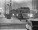
| Date: | 02 02 1967 |
|---|---|
| Description: | Winter scene of a snowstorm that hit Milwaukee just at rush hour creating a traffic headache for homebound commuters (seen here at Wisconsin and Milwaukee ... |
| Date: | 02 1977 |
|---|---|
| Description: | Automobile exhaust on a cold February morning in Milwaukee. |

| Date: | 1969 |
|---|---|
| Description: | Several automobiles and trucks pass through a New York City street. A bridge is visible in the left background, and a construction crane can be seen in the... |

| Date: | 11 12 1951 |
|---|---|
| Description: | Six irate women drivers sit in the office of superior court judge Roy H. Proctor's office to protest his dismissal of a traffic charge against a male drive... |
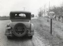
| Date: | 01 1928 |
|---|---|
| Description: | Rear view of a man wearing a wide-brimmed hat stopping an automobile at a stop sign on a dirt road as a truck approaches from the opposite direction. |
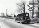
| Date: | 04 23 1926 |
|---|---|
| Description: | A man stops his automobile at a railroad crossing while waiting for the train to cross a paved road. The traffic sign to the right of the car reads: "Railr... |

| Date: | |
|---|---|
| Description: | View down Strong's Avenue, taken from Clark Street. Automobiles park on either side of the street near storefronts. Perpendicular to Strongs Avenue is Main... |
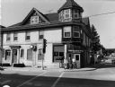
| Date: | 06 08 2001 |
|---|---|
| Description: | "The Slinger House is at 100 W. Washington St. in Slinger, WI, at the intersection of Highway's 175 & 144." |
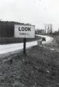
| Date: | 05 1926 |
|---|---|
| Description: | A sign reading: "Look Curve L." is posted along the side of a paved road. An automobile is on the road in the background. |

| Date: | 1920 |
|---|---|
| Description: | This early road map shows the system of roads in Wisconsin, northern Illinois, northeastern Iowa, southeastern Minnesota, and the western portion of Michig... |

| Date: | 1923 |
|---|---|
| Description: | This early road map shows the system of roads in Wisconsin, northern Illinois, northeastern Iowa, southeastern Minnesota, and the western portion of Michig... |

| Date: | 1922 |
|---|---|
| Description: | View down dirt road towards two automobiles, next to each other and going in different directions. Another automobile is parked in the background. On the r... |

| Date: | 1922 |
|---|---|
| Description: | View down dirt road towards a man, seen from behind, sitting on a plow pulled by a team of two horses, near an automobile facing the camera. Next to the au... |

| Date: | 04 1996 |
|---|---|
| Description: | "Solomon Juneau, a devout Catholic, named Henni Street after his friend, Bishop John M. Henni. Bishop Henni (1805-1881) headed the newly designated dioces... |

| Date: | 04 1996 |
|---|---|
| Description: | "Bonduel Street was named after Reverend Fleurimont Bonduel, a missionary from Green Bay. Bonduel, in 1837, celebrated the first mass in Milwaukee in the ... |

| Date: | 1957 |
|---|---|
| Description: | View from inside front seat of an automobile looking toward intersection of Midvale Avenue and Odana Road. |

| Date: | |
|---|---|
| Description: | Three-quarter view from front of man driving a Scout up a hill. In the background are houses on a steep hill behind a fence. |

| Date: | |
|---|---|
| Description: | View across East Washington Avenue towards the Gisholt factory at the intersection of Baldwin Street. There is an enclosed skybridge (called an "overhead" ... |
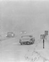
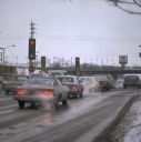
| Date: | 01 1972 |
|---|---|
| Description: | Automobiles are traveling through a winter storm on snow-covered roads. |
If you didn't find the material you searched for, our Library Reference Staff can help.
Call our reference desk at 608-264-6535 or email us at: