 Filter: Subject of automobile driving
Filter: Subject of travel
Filter: Subject of automobile driving
Filter: Subject of travel
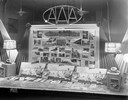
| Date: | 03 28 1939 |
|---|---|
| Description: | American Automobile Association display window showing Wisconsin travel brochures and pictures of tourist destinations around the state. |
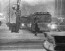
| Date: | 02 02 1967 |
|---|---|
| Description: | Winter scene of a snowstorm that hit Milwaukee just at rush hour creating a traffic headache for homebound commuters (seen here at Wisconsin and Milwaukee ... |
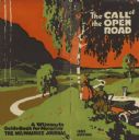
| Date: | 1922 |
|---|---|
| Description: | Front and back cover of the Call of the Open Road, an annual publication of the Milwaukee Journal Tour Department based on its regular columns of mo... |

| Date: | 1925 |
|---|---|
| Description: | Booklet includes maps of Madison, Fond du Lac, Oshkosh, Appleton, Green Bay, Milwaukee, Janesville, Beloit, and La Crosse, Wisconsin and downtown Chicago a... |
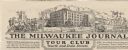
| Date: | |
|---|---|
| Description: | Letterhead of the Milwaukee Journal Tour Club, a national automobile club, with a three-quarter view of the company building surrounded by scenes of a hote... |

| Date: | 1935 |
|---|---|
| Description: | This colored road map comes with a map legend and explanation, as well as an index of cities and towns (and their populations) in Wisconsin. Information ab... |

| Date: | 1936 |
|---|---|
| Description: | This colored road map shows automobile roads in Wisconsin as well as portions of nearby states. Information on the quality and type of any given road (pave... |

| Date: | |
|---|---|
| Description: | This colored road map shows automobile roads in Wisconsin as well as portions of nearby states. Information on the quality and type of any road shown (pave... |

| Date: | 05 02 1923 |
|---|---|
| Description: | Three-quarter view from right rear of a truck adapted with a tent attached to the back while moving down a dirt road. |

| Date: | 1962 |
|---|---|
| Description: | This colored map represents "Tour #2" of a series of driving tours of the state published by the Sperry & Hutchinson Company, in order to "help you enjoy W... |

| Date: | 1952 |
|---|---|
| Description: | This colored map shows the entire state, along with counties in states bordering Wisconsin. There is a key to "Wisconsin Railroads," with initials identify... |

| Date: | 1952 |
|---|---|
| Description: | This colored map shows the entire state, along with counties in states bordering Wisconsin. There is a key to "Wisconsin Railroads," with initials identify... |

| Date: | 1949 |
|---|---|
| Description: | This multi-colored promotional map for recreational activities in the Hayward area includes a graphic of distances from Midwestern cities to Hayward, with ... |
| Date: | 04 24 1958 |
|---|---|
| Description: | Kathleen Russell, Iowa County home agent, backing out of a driveway after visiting a rural home in the county. |

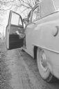
| Date: | 08 30 1958 |
|---|---|
| Description: | Telephoto shot of Labor Day Sunday traffic in Fitchburg on a two lane highway 14 near Clayton Road. Nineteen cars are north bound. Four cars are south bou... |
If you didn't find the material you searched for, our Library Reference Staff can help.
Call our reference desk at 608-264-6535 or email us at: