Filter: Subject of automobile driving
Filter: Subject of water
Filter: Subject of human settlements
Filter: Subject of automobile driving
Filter: Subject of water
Filter: Subject of human settlements
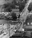
| Date: | 1930 |
|---|---|
| Description: | View down middle of road of car driving across a bridge over Sugar River. Another car is parked by the Wisconsin Power and Light Company. |
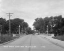
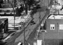
| Date: | |
|---|---|
| Description: | Elevated view of a riverside road with waterfront buildings. One of the buildings has a belltower. |
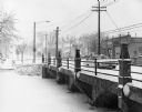
| Date: | 12 1968 |
|---|---|
| Description: | Winter scene of a snowstorm in downtown Theresa. A car drives over a bridge. Mobil gas station in the background. |
| Date: | 1954 |
|---|---|
| Description: | "Telephoto picture of the old bridge. Note Highway is 175." |

| Date: | 1920 |
|---|---|
| Description: | A two-sided map of the state of Wisconsin. The front includes towns and major cities as well as state and county trunk highways. The back includes a smalle... |

| Date: | 1923 |
|---|---|
| Description: | This map shows trails, some in red, for automobiles. The right margin includes a key of markings as well as Minnesota and Wisconsin Highway signs. Communit... |

| Date: | 1929 |
|---|---|
| Description: | View down high bridge of two passenger cars passing one another while crossing over the Mississippi River. |

| Date: | 1923 |
|---|---|
| Description: | This early road map shows the system of roads in Wisconsin, northern Illinois, northeastern Iowa, southeastern Minnesota, and the western portion of Michig... |

| Date: | 1910 |
|---|---|
| Description: | This is a 5 part map showing automobile roads, common roads, cross roads, and railroads. Each map includes a diagram on reverse side and automobile trips o... |

| Date: | 1948 |
|---|---|
| Description: | This blue line print map shows highways, the scale of traffic volume, and average 24 hour traffic. Also included are inset maps of Appleton, Neenah, and Me... |

| Date: | 1919 |
|---|---|
| Description: | This map shows auto trails, main roads, rivers, and populations of communities. The map also shows selected hotels and garages and includes a key in the ri... |

| Date: | 1917 |
|---|---|
| Description: | This road map shows routes through the state as well as some portions of Iowa, Minnesota, and Michigan. Cities, the Mississippi River, Lake Winnebago, Gree... |

| Date: | 1927 |
|---|---|
| Description: | This map details automobile routes throughout the state as well as parts of Iowa, Minnesota, Michigan and Illinois. Cities, the Mississippi River, Lake Mic... |

| Date: | 1910 |
|---|---|
| Description: | This map shows automobile routes across the state as well as Minnesota, Iowa, Illinois, and Michigan. Cities, Lake Michigan, Lake Superior, the Mississippi... |

| Date: | 1915 |
|---|---|
| Description: | This map includes automobile routes through the state as well as routes in parts of Iowa, Michigan and Minnesota. Cities, counties, Lake Michigan, Lake Sup... |

| Date: | 1920 |
|---|---|
| Description: | This map details automobile routes spanning across Wisconsin and parts of Illinois, Michigan, Minnesota, and Iowa. Cities, counties, Lake Michigan, Lake Su... |

| Date: | 1894 |
|---|---|
| Description: | This map shows automobile routes across the state and into parts of Illinois, Michigan, Minnesota, and Iowa. Cities, counties, Lake Michigan, Lake Superior... |

| Date: | 1913 |
|---|---|
| Description: | This map details automobile routes throughout the state and parts of Illinois, Minnesota, Michigan, and Iowa. Cities, counties, Lake Michigan, Lake Superio... |
If you didn't find the material you searched for, our Library Reference Staff can help.
Call our reference desk at 608-264-6535 or email us at: