 Filter: Subject of bays
Filter: Subject of farms
Filter: Subject of bays
Filter: Subject of farms

| Date: | 1915 |
|---|---|
| Description: | This map shows school houses, churches, farms, and railroads. Chequamecon Bay and Bad River Indian Reservation are labeld. The map reads: "All lands shown ... |

| Date: | 1775 |
|---|---|
| Description: | Map of Boston and surrounding regions, from Massachusetts Bay to the Connecticut River, and including part of southern New Hampshire. It shows the colonies... |
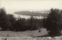
| Date: | 07 29 1946 |
|---|---|
| Description: | Text on front reads: "Little Sister and Sister Bays, Sister Bay, Wis." A view from a hill of the shoreline of Green Bay, Lake Michigan. |
If you didn't find the material you searched for, our Library Reference Staff can help.
Call our reference desk at 608-264-6535 or email us at: