 Filter: Subject of bays
Filter: Subject of forests and forestry
Filter: Subject of bays
Filter: Subject of forests and forestry

| Date: | 1930 |
|---|---|
| Description: | Original map made with watercolor and inkwash. Includes a legend of buildings, roads, natural features and other details of the lodge. Inset at bottom has ... |

| Date: | 1831 |
|---|---|
| Description: | This map shows the land that makes up Michigan, Wisconsin, Minnesota, Indiana, and parts of Canada. The Great Lakes are displayed prominently, along with s... |
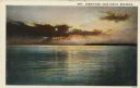
| Date: | 1932 |
|---|---|
| Description: | Color postcard view of a brilliant sunset over Green Bay. There is a forested shoreline in the distance. Caption reads: "Sunset View, Door County, Wisconsi... |
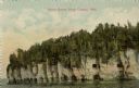
| Date: | |
|---|---|
| Description: | View across water towards the bluffs at the northern end of Door County. |

| Date: | 1719 |
|---|---|
| Description: | Map of Maryland and surrounding states. It shows the boundaries, counties, cities, towns, rivers, and bays. Mountains, forests, and swamps appear pictoria... |

| Date: | 1795 |
|---|---|
| Description: | Map of New Jersey showing counties, cities, towns, mills, landowners, roads, mountains, bays, rivers, and lakes. A few annotations dot the map, describing... |

| Date: | 1667 |
|---|---|
| Description: | Map of Virginia depicting the discoveries detailed by John Smith in his exploration of the region. It shows Jamestown, Native American tribes and villages,... |

| Date: | 1671 |
|---|---|
| Description: | Map of Virginia depicting the discoveries detailed by John Smith in his exploration of the region. It shows Jamestown, Native American tribes and villages,... |

| Date: | 1676 |
|---|---|
| Description: | Map of Virginia and Maryland, based on John Smith's 1612 map and Augustine Herman's 1673 seminal map. It shows borders, counties, Native American land, tri... |

| Date: | 1761 |
|---|---|
| Description: | Map covering southern Louisiana from Lake Ponchetrain to the Golf of Mexico and from Woods Bay in the west to the islands just east of Bay St. Louis. It sh... |

| Date: | 1759 |
|---|---|
| Description: | Map of New Orleans at the start of the French & Indian War, including two inset maps entitled "The Course of the Mississipi River from Bayagoulas to the Se... |

| Date: | 1769 |
|---|---|
| Description: | Map of New Orleans at the start of the French & Indian War, including two inset maps of the Mississippi River Delta and Fort la Balise. It shows streets, r... |

| Date: | 1933 |
|---|---|
| Description: | This map contains automobile routes across Wisconsin and portions of Illinois, Iowa, Minnesota and Michigan as well. The state borders are clearly defined... |
| Date: | |
|---|---|
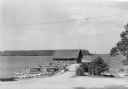
| Description: | View of Beach Road and the beach at Ellison Bay. Buildings are across the bay, and a tree-lined ridge is in the far background. Caption reads: "Beach Road,... |

| Date: | 1952 |
|---|---|
| Description: | Kodachrome reproduction of the view over the rooftops of Ephraim towards Eagle Bay. Text on reverse reads: "Portraying the beauty and charm of picturesq... |
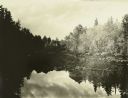
| Date: | 1910 |
|---|---|
| Description: | A view at the end of a bay of mirror images of trees on a lake. |
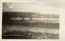
| Date: | 1935 |
|---|---|
| Description: | Canoes and small sailboats are pulled up on the shore or tied up to the piers extending from the wharf at Ellison Bay. There is a small warehouse on the wh... |
| Date: | 1950 |
|---|---|
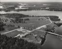
| Description: | Aerial view of Northernaire Resort, on Deer Lake. The resort is in the foreground. Many lakes, surrounded by trees, are in the background, including Big St... |
| Date: | 1963 |
|---|---|
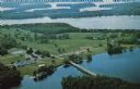
| Description: | Text on reverse reads: "Northernaire, Three Lakes, WI 54562. Phone 715 – 546-3331. The Resort Hotel that has it all." Aerial view of Northernaire Resort, o... |
If you didn't find the material you searched for, our Library Reference Staff can help.
Call our reference desk at 608-264-6535 or email us at: