 Filter: Subject of bays
Filter: Subject of men
Filter: Subject of bays
Filter: Subject of men

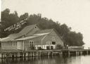
| Date: | 1912 |
|---|---|
| Description: | View across water toward buildings on the right, with men standing on a platform at the shoreline in front of a large building. Three more smaller building... |

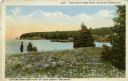
| Date: | 1954 |
|---|---|
| Description: | View looking west from Eagle Bluff toward Nicolet Bay, the Strawberry Islands, and Chambers Island. Three people are sitting on the stone wall of the overl... |

| Date: | 1957 |
|---|---|
| Description: | Large Letter style postcard for Green Bay depicting various scenes in the letters that spell the name of the city. Caption reads: "Greetings from Green Bay... |
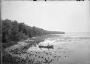
| Date: | 1900 |
|---|---|
| Description: | Slightly elevated view of the west shore of Turville Bay. Two men sit in a rowboat near the shore surrounded by water lilies. There is a fence in the foreg... |
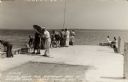
| Date: | 1940 |
|---|---|
| Description: | Photographic postcard view looking out at people standing, and some fishing, on the Northport pier at Death's Door, with the bay in the background. |
| Date: | |
|---|---|
| Description: | View across water towards a group of people, men, woman, and young girls and boys, posing on a pier in front of a building on the shoreline of Sister Bay. ... |

| Date: | 1930 |
|---|---|
| Description: | Original map made with watercolor and inkwash. Includes a legend of buildings, roads, natural features and other details of the lodge. Inset at bottom has ... |

| Date: | 01 2014 |
|---|---|
| Description: | View from shoreline on a sunny day of snow-covered, frozen Monona Bay. People in the distance are standing or sitting near ice fishing holes and ice fishin... |

| Date: | 1710 |
|---|---|
| Description: | A seminal and fairly accurate map of the Great Lakes Region up to Baffin's Bay in Northern Canada. This is possibly the first printed map to locate Detroit... |

| Date: | 1683 |
|---|---|
| Description: | Map of the north east coast of North America showing islands, regions, Native American land, bays, and a few European settlements. The Great Lakes appear i... |
| Date: | |
|---|---|
| Description: | Colored postcard view near the extreme northern point of Door County. There is a man standing on the left in a field of flowers looking at the bay. Fishing... |

| Date: | 1667 |
|---|---|
| Description: | Map of Virginia depicting the discoveries detailed by John Smith in his exploration of the region. It shows Jamestown, Native American tribes and villages,... |

| Date: | 1671 |
|---|---|
| Description: | Map of Virginia depicting the discoveries detailed by John Smith in his exploration of the region. It shows Jamestown, Native American tribes and villages,... |

| Date: | 1755 |
|---|---|
| Description: | Map of Virginia and parts of Maryland, North Carolina, and New Jersey. It shows borders, boundary lines, some Native American land, counties, cities, towns... |

| Date: | 1761 |
|---|---|
| Description: | Map covering southern Louisiana from Lake Ponchetrain to the Golf of Mexico and from Woods Bay in the west to the islands just east of Bay St. Louis. It sh... |
| Date: | |
|---|---|
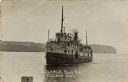
| Description: | View of the Steamer "Bon Ami" on Ellison Bay. A few people are on the deck. The tree-lined far shoreline is in the background. Caption reads: "Steamer Bon ... |
| Date: | |
|---|---|
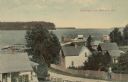
| Description: | Elevated view from hill of the bay and Ephraim. A man is walking up the hill on a road with buildings and fences on both sides. Caption reads: "Greetings f... |
| Date: | 1907 |
|---|---|
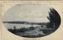
| Description: | Oval framed view of Ephraim from across the bay. A man is standing in the foreground. Caption reads: "Greetings from Ephraim, Wis." |
| Date: | 1907 |
|---|---|
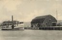
| Description: | View across water towards the Fish Creek Dock with a boathouse, and a steamer pulling up from the left. A group of people are gathered on the dock. Caption... |

| Date: | 1967 |
|---|---|
| Description: | View across grass and sand towards a young couple, a man and woman, holding hands and walking along the shoreline of Whitefish Bay. Trees are along the cur... |
If you didn't find the material you searched for, our Library Reference Staff can help.
Call our reference desk at 608-264-6535 or email us at: