 Filter: Subject of botany
Filter: Subject of northeastern states
Filter: Subject of botany
Filter: Subject of northeastern states
| Date: | |
|---|---|
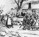
| Description: | Thanksgiving dinner between Native Americans and early Pilgrim settlers in America. |
| Date: | |
|---|---|
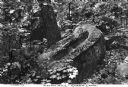
| Description: | View of a large carved rock on a forest floor surrounded by maple tree saplings. The rock has carved indentations for use as a mortar stone and was probabl... |
| Date: | 1882 |
|---|---|
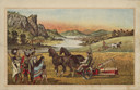
| Description: | Back cover of catalog with an illustration of two men using horse-drawn agricultural machinery in fields, while a group of Native American Indians look on.... |

| Date: | 1755 |
|---|---|
| Description: | Map of New England, with three inset maps of Fort Oswego, Fort du Quesne, and Fort Frederick. It shows colonies, a few cities, forts (marked as French or E... |

| Date: | 1756 |
|---|---|
| Description: | Map of Pennsylvania, showing cities, towns, roads, trading paths, portages, forts, mountains, swamps, waterfalls, lakes, and rivers. The map further includ... |
If you didn't find the material you searched for, our Library Reference Staff can help.
Call our reference desk at 608-264-6535 or email us at: