 Filter: Subject of botany
Filter: Subject of surveying
Filter: Subject of botany
Filter: Subject of surveying
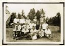
| Date: | 1932 |
|---|---|
| Description: | Group portrait of a group of Wisconsin Land Economic Inventory workers. John Bordner is in the center of the top row. Stanta Bordner is beside him. Uppe... |
| Date: | 04 23 1937 |
|---|---|
| Description: | Sand barrens being used for poor crops. Note on back of print reads: "This should be in timber." |

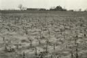
| Date: | 04 1937 |
|---|---|
| Description: | From back of print: "Dane County, Town of Middleton, north 1/2 section of section 17 looking SW from a hill across the valley showing erosion and stump pas... |
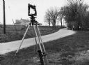
| Date: | 1970 |
|---|---|
| Description: | "Surveying Crew on McArthur Rd. Sunny Brae farm is in background." |
| Date: | |
|---|---|
| Description: | Letterhead of H.I. Bliss, a real estate agent, civil engineer, and county surveyor in La Crosse, Wisconsin. On the left a group of three men are surveying ... |

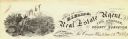
| Date: | 1923 |
|---|---|
| Description: | This topographical map of Devil's Lake State Park, Sauk County, Wisconsin, is based on 1922-1923 surveys of the area by the University of Wisconsin Summer ... |
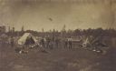
| Date: | 07 01 1871 |
|---|---|
| Description: | Railroad surveying party in camp somewhere north of Green Bay. The men were surveyors for the Chicago & Northwestern railroad extension. |
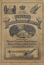
| Date: | 1886 |
|---|---|
| Description: | Front cover featuring illustrations of wheeled scrapers, drag scrapers, railroad plows and road graders. |

| Date: | 1930 |
|---|---|
| Description: | Original map made with watercolor and inkwash. Includes a legend of buildings, roads, natural features and other details of the lodge. Inset at bottom has ... |

| Date: | 1784 |
|---|---|
| Description: | Map showing fifty thousand acres of land in what will later become Kentucky, broken up into parcels labeled 1 through 50. No features are labeled, but the ... |
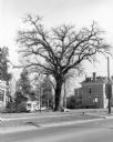
| Date: | 1981 |
|---|---|
| Description: | View across street towards a very tall bur oak towering over nearby houses at the corner of Main and Franklin Streets. There is a small monument at its bas... |

| Date: | 1982 |
|---|---|
| Description: | A segment of the trunk of a pine bears the scars of a "blaze" carved with an ax and bearing the inscription: "XIX T. J. Cram, D. Houghton Aug 11, 1841." C... |
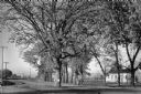
| Date: | 1955 |
|---|---|
| Description: | A large, spreading bur oak standing directly in the intersection of Hammond and Hanerville Roads, both unpaved. There is a row of smaller trees lining Hane... |
If you didn't find the material you searched for, our Library Reference Staff can help.
Call our reference desk at 608-264-6535 or email us at: