 Filter: Subject of botany
Filter: Subject of trees
Filter: County of Dane
Filter: Type of Map or Atlas
Filter: Subject of botany
Filter: Subject of trees
Filter: County of Dane
Filter: Type of Map or Atlas

| Date: | 1876 |
|---|---|
| Description: | Bird's-eye view of Middleton with an inset of a school house. |

| Date: | 1875 |
|---|---|
| Description: | Bird's-eye map of Mazomanie. |
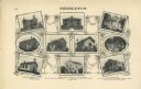
| Date: | 1911 |
|---|---|
| Description: | "Standard Historical Atlas of Dane County, Wisconsin." Top half of page 98, showing all of the different district schools in Middleton. |

| Date: | 1880 |
|---|---|
| Description: | This map is pen-and-ink on paper. The map shows buildings, trees, and water and gas pipes, relief is shown by contours. The back of the map reads: "Univers... |

| Date: | 1855 |
|---|---|
| Description: | This bird's-eye-view map of Madison is looking north across Lake Monona. The map features two women and two men on a lookout on top of a building in the fo... |

| Date: | 04 1905 |
|---|---|
| Description: | Map of the Madison, Wisconsin region showing the four major lakes, starting in the north with Lake Mendota, Lake Monona, Lake Waubesa, and Lake Kegonsa. La... |

| Date: | 10 1911 |
|---|---|
| Description: | This map shows lot numbers, building lines, roads, trees, and Indian mounds. Relief is shown by contours. Includes manuscript annotations marking parks. |

| Date: | 1920 |
|---|---|
| Description: | This map, with north oriented to the right, shows a plat of the area, numbered blocks and lots, local streets, roads, parks, a proposed golf course, and la... |
If you didn't find the material you searched for, our Library Reference Staff can help.
Call our reference desk at 608-264-6535 or email us at:

