 Filter: Subject of botany
Filter: Subject of wetlands
Filter: Subject of botany
Filter: Subject of wetlands
| Date: | 1910 |
|---|---|
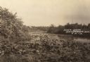
| Description: | A river scene, presumably Soft Maple Creek. Caption reads: "River Scene, Weyerhauser, Wis." |

| Date: | 1930 |
|---|---|
| Description: | A view looking west at Rib Mountain across the Wisconsin River from the outskirts of Wausau. |

| Date: | 1964 |
|---|---|
| Description: | This 1964 map of Madeline Island, Ashland County, Wisconsin, shows existing and historical locations, roads, the boundaries of a proposed state park, secti... |

| Date: | 1914 |
|---|---|
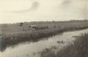
| Description: | View of a drainage ditch in Horicon Marsh. A man is on a path along the left of the ditch. |

| Date: | 10 1914 |
|---|---|
| Description: | View of furrowed ground in Horicon Marsh and men on a tractor in the process of plowing a drained portion of the marsh. |

| Date: | |
|---|---|
| Description: | "Section of New Prairie du Chien Marquette $1,000,000 Suspension Bridge. Total length 3729 feet. Only suspension bridge on the Mississippi River. Open for ... |

| Date: | 1929 |
|---|---|
| Description: | Elevated view from Signal Point of the Mississippi River, railroad and surrounding forest and wetlands. |

| Date: | |
|---|---|
| Description: | A bird's eye view overlooking the Mississippi River, sand bars, the railroad bridge, surrounding forests and wetlands. |

| Date: | 1969 |
|---|---|
| Description: | This photograph was likely taken by the International Harvester Overseas Division for promotional purposes, and shows a man driving an International Harves... |
| Date: | 07 12 1964 |
|---|---|
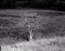
| Description: | Dead tree at the edge of a marsh. The background fades to black. |
| Date: | 1918 |
|---|---|
| Description: | Elevated view across stream in marshy area towards a group of people gathered around an aircraft wreck. |

| Date: | 1975 |
|---|---|
| Description: | This map shows boundaries, roads, national forest land, bogs and wetlands, lakes, campgrounds, and boat landings. |

| Date: | 1906 |
|---|---|
| Description: | Watercolor painting of the Yahara River at Lake Monona, with trees in the background and wetlands in the foreground. |

| Date: | 1906 |
|---|---|
| Description: | Watercolor painting of the Yahara River, with large trees on the shoreline. Note: '05 & '06 were the years when Tenney Park and the Yahara River Parkway ... |
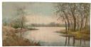
| Date: | |
|---|---|
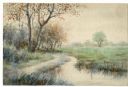
| Description: | Watercolor painting of the Yahara River north of Lake Mendota. Trees are on the banks to the left with foliage throughout. A meadow is on the right. |
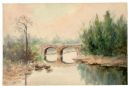
| Date: | |
|---|---|
| Description: | Watercolor painting of a bridge over a river, with pine trees on the right and a lone tree and foliage on the left. |
| Date: | |
|---|---|
| Description: | Watercolor painting of the Yahara River with trees and foliage on the banks. In the background trees line the far shore. |

| Date: | 1973 |
|---|---|
| Description: | This map shows the uses of land in St. Croix County. Uses are indicated by colored dots. Residential(Yellow), Commercial(Red), Industrial(Grey), Parks and ... |

| Date: | 1970 |
|---|---|
| Description: | This map shows colored-coded land use with a legend in the bottom margin. Land classifications include: Year-round Residential (yellow), Seasonal Residenti... |

| Date: | 1973 |
|---|---|
| Description: | This map is 1 of 7 and includes a location map and township diagram in the margins. The map includes a key of land type: Residential (yellow), Commercial (... |
If you didn't find the material you searched for, our Library Reference Staff can help.
Call our reference desk at 608-264-6535 or email us at: