 Filter: Subject of camps
Filter: Subject of tourism
Filter: Subject of camps
Filter: Subject of tourism

| Date: | 06 11 1931 |
|---|---|
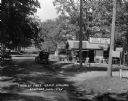
| Description: | View down road towards the Log Cabin tourist camp at 6611 University Avenue. |
| Date: | 1929 |
|---|---|
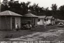
| Description: | Bartlett's Cabin Camp on Highways 10 &12 near Eau Claire. |

| Date: | 1925 |
|---|---|
| Description: | The Olin Park tourist campground on the shore of Lake Monona in Madison. |
| Date: | 1925 |
|---|---|
| Description: | The free tourist campground in Baraboo. Although similar free facilities were clustered in resort areas, by 1926 the Highway Commission engineer could rep... |
| Date: | 1925 |
|---|---|
| Description: | Free public campground at Baraboo, one of 200 such facilities then made available to the traveling public by Wisconsin municipalities. |
| Date: | 06 1959 |
|---|---|
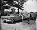
| Description: | Two men with cameras around their necks stand near a couple in a Plymouth pulling an airstream camper through a gate. The sign on the gate in the backgroun... |
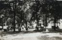
| Date: | 04 13 1925 |
|---|---|
| Description: | View down dirt road of people standing beneath the trees at Ottawa Park Tourist Camp. Automobiles are parked in the background, and tents are set up throug... |

| Date: | 1926 |
|---|---|
| Description: | This 1926 map depicts resorts and camps, lakes and streams, railroads, and roads in portions of Vilas, Iron, Oneida, Price, and Lincoln counties in Wiscons... |

| Date: | 1967 |
|---|---|
| Description: | This tourist brochure for Bayfield County, Wisconsin, from 1967 includes a map of the county showing towns, cities and villages, highways and roads, railro... |
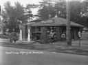
| Date: | 1931 |
|---|---|
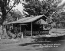
| Description: | A view of the Log Cabin Filling Station at a tourist camp. A garage for washing and greasing on the left. Two tall gas pumps. Lamps made of interlaced logs... |
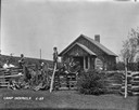
| Date: | 1929 |
|---|---|
| Description: | A group of young boys with their male camp counselors are sitting and standing around the split-rail fence. There is a log cabin and a cornfield in the bac... |
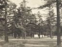
| Date: | 1925 |
|---|---|
| Description: | Stand of pine trees and pitched tents, with automobiles, in the Marinette Tourist Camp. |

| Date: | 1939 |
|---|---|
| Description: | This brochure was intended for tourists and shows resorts, lakes and railroads in northwestern Wisconsin and part of Michigan’s upper peninsula. Also inclu... |

| Date: | 1969 |
|---|---|
| Description: | This map shows ski areas, resorts, camps, special areas, airports, and roads. The map covers Vilas and Oneida counties and parts of Iron, Price, Lincoln, L... |

| Date: | 1940 |
|---|---|
| Description: | This map shows lakes, roads, car trails, foot trails, railroads, resorts and camps, and fire towers. The map includes an inset location map and pictorial d... |
If you didn't find the material you searched for, our Library Reference Staff can help.
Call our reference desk at 608-264-6535 or email us at: