 Filter: Subject of camps
Filter: Subject of trails
Filter: Subject of camps
Filter: Subject of trails

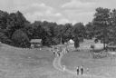
| Date: | 07 27 1948 |
|---|---|
| Description: | Four campers hike along a trail at Camp Wakanda, left to right: Raymond Nagel, son of Mr. and Mrs. Henry Nagel, 2810 Dahl Street, Carl Fosmark, son of Dr. ... |

| Date: | 07 06 1950 |
|---|---|
| Description: | Girl Scouts carry water up a hill to their camp site at Camp Greenwood, a day camp at Picnic Point for Intermediate Girl Scouts between the ages of 10 and ... |
| Date: | 1940 |
|---|---|
| Description: | A view of a cabin and the tent grounds of Nordland Camp for boys, operated as an auxiliary of the German-American Bund, the American Nazi Organization. A f... |
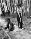
| Date: | 05 15 1954 |
|---|---|
| Description: | Two campers working on a trail during the seventh and eighth grade Girl Scouts play day at the Black Hawk Council's Camp Brandenburg. Lois Lischeske of Mad... |

| Date: | 1916 |
|---|---|
| Description: | This Wisconsin Conservation Commission map from 1916 shows Peninsula State Park in the Town of Gibraltar, Door County, Wisconsin. Depicted are open and pla... |

| Date: | 1916 |
|---|---|
| Description: | This version of a 1916 Wisconsin Conservation Commission map shows Peninsula State Park in the Town of Gibraltar, Door County, Wisconsin. Depicted are open... |

| Date: | 1800 |
|---|---|
| Description: | This map of the Little Kaukalin Region is ink on paper and shows Little Kaukalin Rapids, Black Bird Island, buildings, trails, meadows and woods, and a sug... |
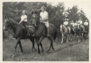
| Date: | |
|---|---|
| Description: | Group of campers and a camp counselor riding on horseback on a trail in wooded area. Original caption notes: "Riding is one of the most popular sports. Eng... |

| Date: | 1952 |
|---|---|
| Description: | This map shows roads, foot and canoe trails, railroads, resorts, lookout towers, camps, national and state forests, Indian reservation, and types of fish i... |

| Date: | 1940 |
|---|---|
| Description: | This map shows lakes, roads, car trails, foot trails, railroads, resorts and camps, and fire towers. The map includes an inset location map and pictorial d... |
If you didn't find the material you searched for, our Library Reference Staff can help.
Call our reference desk at 608-264-6535 or email us at: