 Filter: Subject of capitol buildings
Filter: Subject of land
Filter: Community of Madison
Filter: Subject of capitol buildings
Filter: Subject of land
Filter: Community of Madison

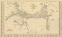
| Date: | 1908 |
|---|---|
| Description: | Colored map showing a panoramic view of Madison in great detail. The Wisconsin State Capitol is located at the center, with Lake Mendota in the background ... |

| Date: | 05 09 1908 |
|---|---|
| Description: | Kite aerial panoramic photograph of the central business district. In the distance is Lake Mendota. The fire damaged Wisconsin State Capitol is in the cent... |

| Date: | 1885 |
|---|---|
| Description: | Bird's-eye map of Madison, State Capital of Wisconsin, County Seat of Dane County, with inset of the Wisconsin State Capitol. |

| Date: | 1955 |
|---|---|
| Description: | An air view of Madison's downtown area with the Wisconsin State Capitol and new State Office Buildings. |

| Date: | 1930 |
|---|---|
| Description: | Aerial view of isthmus looking east toward Lake Mendota and the Wisconsin State Capitol, with Lake Monona and the horizon in the background. |

| Date: | 07 05 1933 |
|---|---|
| Description: | View from shoreline of tree-lined distant shore, beyond which can be seen the dome of the Wisconsin State Capitol, and on the right, St. Raphael's Catholic... |

| Date: | 1925 |
|---|---|
| Description: | View from Olin Park looking at the Madison skyline. |
| Date: | 1930 |
|---|---|
| Description: | This map is indexed with the north oriented toward the upper right. The map includes a collection manuscript annotations. |

| Date: | 1896 |
|---|---|
| Description: | Shows pipes of various sizes, hydrants with hydrant pressure, valves, wells, projected lines, and suction pipes. Differs from earlier versions by inclusion... |

| Date: | 1905 |
|---|---|
| Description: | View of Madison in the far distance taken from the third floor of a home at 216 Campbell Street, in University Heights. There is a power line suspended in ... |
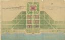
| Date: | 07 1939 |
|---|---|
| Description: | An architectural rendering of a proposed lakefront development plan. |

| Date: | 1908 |
|---|---|
| Description: | Kite aerial panoramic photograph of the central business district. In the distance is Lake Mendota. The fire damaged Wisconsin State Capitol is in the cent... |
If you didn't find the material you searched for, our Library Reference Staff can help.
Call our reference desk at 608-264-6535 or email us at: