 Filter: Subject of capitol buildings
Filter: Subject of recreation areas
Filter: Subject of streets
Filter: Subject of capitol buildings
Filter: Subject of recreation areas
Filter: Subject of streets
| Date: | |
|---|---|
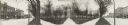
| Description: | Haines Photo Co. panoramic photo of Madison's Capitol Square, taken from the King Street corner. |

| Date: | 1929 |
|---|---|
| Description: | This is a blue line print map that shows local streets, railroads, local businesses, schools, parks, cemeteries, the airport, the state capitol, the Univer... |
If you didn't find the material you searched for, our Library Reference Staff can help.
Call our reference desk at 608-264-6535 or email us at: