 Filter: Subject of capitol buildings
Filter: Subject of water
Filter: Subject of intellectual life
Filter: Subject of capitol buildings
Filter: Subject of water
Filter: Subject of intellectual life

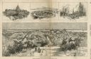
| Date: | 1908 |
|---|---|
| Description: | Colored map showing a panoramic view of Madison in great detail. The Wisconsin State Capitol is located at the center, with Lake Mendota in the background ... |

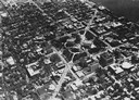
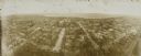
| Date: | 05 09 1908 |
|---|---|
| Description: | Kite aerial panoramic photograph of the central business district. In the distance is Lake Mendota. The fire damaged Wisconsin State Capitol is in the cent... |

| Date: | 1885 |
|---|---|
| Description: | Bird's-eye map of Madison, State Capital of Wisconsin, County Seat of Dane County, with inset of the Wisconsin State Capitol. |
| Date: | 03 30 1889 |
|---|---|
| Description: | Bird's-eye view from Bascom Hill of Madison, with vignettes of the Wisconsin State Capitol, Lake Monona, and the Capitol Park. |

| Date: | 1922 |
|---|---|
| Description: | Aerial view of the Wisconsin State Capitol and Lake Monona. |

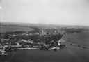
| Date: | 1934 |
|---|---|
| Description: | Aerial view of Capitol and Lake Mendota and Lake Monona. |

| Date: | 1948 |
|---|---|
| Description: | Aerial view of the Wisconsin State Capitol and surrounding area looking south southeast towards Lake Monona. |

| Date: | 1955 |
|---|---|
| Description: | An air view of Madison's downtown area with the Wisconsin State Capitol and new State Office Buildings. |

| Date: | 1930 |
|---|---|
| Description: | Aerial view of isthmus looking east toward Lake Mendota and the Wisconsin State Capitol, with Lake Monona and the horizon in the background. |
| Date: | 1928 |
|---|---|
| Description: | Aerial view of Capitol Square and vicinity, looking east-northeast. State Street is visible at the bottom center. |
| Date: | 1930 |
|---|---|
| Description: | Aerial view of the Isthmus and the city of Madison including the downtown business district, the Wisconsin State Capitol, both Lake Mendota and Lake Monona... |

| Date: | 1930 |
|---|---|
| Description: | Aerial view of the University of Wisconsin-Madison campus including Camp Randall Stadium, the Wisconsin State Capitol, and both Lake Mendota and Lake Monon... |
| Date: | 1860 |
|---|---|
| Description: | Jefferson Davis walks a tightrope over a waterfall heading toward the side of a cliff on which is the Capitol building, a soldier, and the Union flag. Behi... |

| Date: | 1937 |
|---|---|
| Description: | Pictorial map showing historical events and locations within the state of Wisconsin, as well as waterways and counties. Original caption on the bottom marg... |
| Date: | 1908 |
|---|---|
| Description: | Kite aerial panoramic photograph of the central business district. In the distance is Lake Mendota. The fire damaged Wisconsin State Capitol is in the cent... |

| Date: | 1942 |
|---|---|
| Description: | Aerial view of Capitol Square with Lake Monona in the foreground and Lake Mendota in the background. Pinckney Street is on the right. |
If you didn't find the material you searched for, our Library Reference Staff can help.
Call our reference desk at 608-264-6535 or email us at:
