 Filter: Subject of capitol buildings
Filter: Subject of water
Filter: Subject of capitol buildings
Filter: Subject of water

| Date: | |
|---|---|
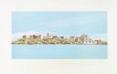
| Description: | Elevated view of the Wisconsin State Capitol with Lake Monona in the background. |
| Date: | 12 11 1970 |
|---|---|
| Description: | Caption on back reads, "Given by 1st National Bank to student customers, 11-XII-70 [12/11/70]. This is the design of their new 'Madisonian' checks." Depi... |
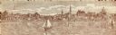
| Date: | 1900 |
|---|---|
| Description: | A view of the city of Madison circa 1900 that was used as a letterhead. |
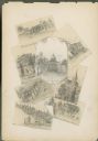
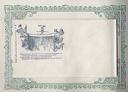
| Date: | 1885 |
|---|---|
| Description: | Wisconsin State Capitol surrounded by seven miniature drawings of Madison images. |

| Date: | 1904 |
|---|---|
| Description: | View from railroad bed along Monona Bay shoreline. The Wisconsin State Capitol dome is under construction. St. Raphael's Cathedral can be seen on the left. |

| Date: | 12 14 1976 |
|---|---|
| Description: | View of Lake Mendota and shoreline from University Bay Drive. Snow covers the lake and the shore. |

| Date: | 07 05 1933 |
|---|---|
| Description: | View from shoreline of tree-lined distant shore, beyond which can be seen the dome of the Wisconsin State Capitol, and on the right, St. Raphael's Catholic... |
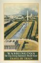
| Date: | 1934 |
|---|---|
| Description: | An original lithograph promoting Washington, D.C. as "the city that every American should know," and to get there by way of train travel. The poster depict... |

| Date: | |
|---|---|
| Description: | Wisconsin Governor Tommy G. Thompson waves from a Harley Davidson motorcycle as he rides on John Nolen Drive. Lake Monona and the Wisconsin State Capitol b... |
| Date: | 1860 |
|---|---|
| Description: | Jefferson Davis walks a tightrope over a waterfall heading toward the side of a cliff on which is the Capitol building, a soldier, and the Union flag. Behi... |

| Date: | 1925 |
|---|---|
| Description: | View from Olin Park looking at the Madison skyline. |

| Date: | 1835 |
|---|---|
| Description: | Plat for a proposed Sinsinawa City (never built), in Grant County, Wis. When it became clear in the mid-1830s that Wisconsin Territory would be established... |
| Date: | 1930 |
|---|---|
| Description: | This map is indexed with the north oriented toward the upper right. The map includes a collection manuscript annotations. |

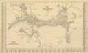
| Date: | 1896 |
|---|---|
| Description: | Shows pipes of various sizes, hydrants with hydrant pressure, valves, wells, projected lines, and suction pipes. Differs from earlier versions by inclusion... |

| Date: | 1929 |
|---|---|
| Description: | This is a blue line print map that shows local streets, railroads, local businesses, schools, parks, cemeteries, the airport, the state capitol, the Univer... |
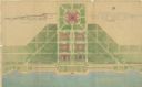
| Date: | 07 1939 |
|---|---|
| Description: | An architectural rendering of a proposed lakefront development plan. |

| Date: | 1937 |
|---|---|
| Description: | Pictorial map showing historical events and locations within the state of Wisconsin, as well as waterways and counties. Original caption on the bottom marg... |
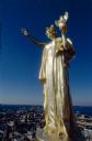
| Date: | 11 1990 |
|---|---|
| Description: | Close-up of the statue "Wisconsin," created by Daniel Chester French and situated on top of the dome of the Wisconsin State Capitol, immediately after clea... |

| Date: | 1970 |
|---|---|
| Description: | This photocopy map shows the locations of historic buildings, as well as all other buildings in the isthmus. The map also includes photographs of selected ... |

| Date: | 06 16 2015 |
|---|---|
| Description: | Children and adults at a small, sandy beach on the bay. Two woman are watching over the children as they play in the water or on the beach. The skyline of ... |
If you didn't find the material you searched for, our Library Reference Staff can help.
Call our reference desk at 608-264-6535 or email us at: