 Filter: Subject of dwellings
Filter: Subject of coasts
Filter: Subject of dwellings
Filter: Subject of coasts
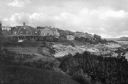
| Date: | 1920 |
|---|---|
| Description: | View along top of cliff toward cottages along a rocky coast. A large building is in the distance on the right. |
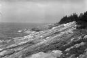
| Date: | |
|---|---|
| Description: | View of the rocky coast of Maine as seen from a hillside. The rooftop of a dwelling is visible above a pine forest at right. |

| Date: | |
|---|---|
| Description: | A couple walks along a sandy shoreline. Dwellings and buildings are visible in the background. |

| Date: | |
|---|---|
| Description: | View along shoreline toward a lighthouse and homes standing on Rocky Point. There are several boats anchored at the shore and in the water. |
| Date: | |
|---|---|
| Description: | Homes stand along the coast near cliffs on Block Island. |
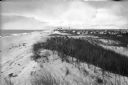
| Date: | |
|---|---|
| Description: | View from beach dunes looking north. View features many plants on sand dunes in the forefront, and people on a sandy beach, many dwellings, and a flag in t... |

| Date: | |
|---|---|
| Description: | Elevated view of Bermuda shoreline. Several dwellings stand on top of the island and people swim in the ocean on the beaches below. |

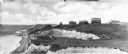
| Date: | 1990 |
|---|---|
| Description: | Color photo of an International school bus driven along a coastal road. In the foreground is a split-rail fence and lawn. The photograph was probably taken... |

| Date: | 1902 |
|---|---|
| Description: | Elevated view of the city of Port Limon, Costa Rica with the Caribbean Sea in the background. Trees grow amongst the many commercial and residential buildi... |

| Date: | 1780 |
|---|---|
| Description: | This map shows the townships, parishes, cities, towns, plantations, lakes, rivers, swamps, and roads near the coast of South Carolina and Georgia. Emphasis... |

| Date: | 1783 |
|---|---|
| Description: | Map of eastern Canada and part of America, with an inset map of the Great Lakes region in the lower left corner. It shows boundaries, cities, settlements, ... |

| Date: | 1776 |
|---|---|
| Description: | Map showing New England, Nova Scotia, and Newfoundland, based on the seminal work of D' Anville, as well as the works of Belllin and de Vaugondy. It shows ... |

| Date: | 1667 |
|---|---|
| Description: | Map of Virginia depicting the discoveries detailed by John Smith in his exploration of the region. It shows Jamestown, Native American tribes and villages,... |
If you didn't find the material you searched for, our Library Reference Staff can help.
Call our reference desk at 608-264-6535 or email us at: