 Filter: Subject of dwellings
Filter: Subject of great lakes
Filter: Subject of dwellings
Filter: Subject of great lakes

| Date: | 1900 |
|---|---|
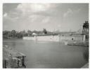
| Description: | View of La Pointe, Madeline Island, taken from the Mission Inn. |

| Date: | 1900 |
|---|---|
| Description: | The house of Captain Angus on the shore of Lake Superior in La Pointe on Madeline Island sometime around 1900. The Angus family came to Madeline Island in ... |

| Date: | 1886 |
|---|---|
| Description: | Bird's-eye view of Ashland, on the shores of Lake Superior, with insets of The Apostle Islands Chequamagon Bay & Ashland, and Distances from Ashland. |
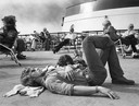
| Date: | 08 29 1977 |
|---|---|
| Description: | Ferry boat passengers on the deck of the SS City of Midland sun themselves as they cross Lake Michigan from Milwaukee, Wisconsin to Ludington, Michi... |

| Date: | 1632 |
|---|---|
| Description: | The Wisconsin portion of Champlain's 1632 map, augmented since the previous one, for navigation according to the true Meridien, by Sieur de Champlain. The ... |
| Date: | |
|---|---|
| Description: | Hand-colored view of the Thordarson estate including the boathouse and a stone-paved path with benches. |
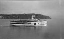
| Date: | |
|---|---|
| Description: | View of the steamer ship "Islander" leaving Mackinac Island. Signs painted on the ship reads=: "Islander," "Arnold Line" and "St. Ignace Mackinac Island" (... |

| Date: | 1935 |
|---|---|
| Description: | View of six men sitting on rattan furniture on a covered boat deck. Three men are wearing hats, and one man is smoking a cigar. Off the bow of the boat an ... |
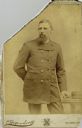
| Date: | |
|---|---|
| Description: | Three-quarter length cabinet card portrait of Captain N.A. Peterson, a native of Milwaukee, Wisconsin, who was master and part owner of the schooner “Selt”... |

| Date: | 1785 |
|---|---|
| Description: | Map of part of North America engraved and hand-colored (the light brown design is a superposition of the map and cartouche derived from the oxidation of th... |
| Date: | 07 02 1960 |
|---|---|
| Description: | View across water towards the Manitowoc Shipbuilding floating drydock. Pilings and grass are in the foreground. On the far shoreline are buildings on a hil... |
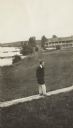
| Date: | 1913 |
|---|---|
| Description: | Jesse Stone walking on board sidewalk, with the Mission Inn along the shoreline in the background. |
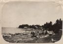
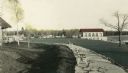
| Date: | 1910 |
|---|---|
| Description: | View along shoreline of Weborg Point before the area became Peninsula State Park. Green Bay is on the left. Two wood buildings are along the shoreline in t... |

| Date: | 1783 |
|---|---|
| Description: | Map of eastern Canada and part of America, with an inset map of the Great Lakes region in the lower left corner. It shows boundaries, cities, settlements, ... |
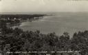
| Date: | |
|---|---|
| Description: | Elevated view of Green Bay from the Alpine Tower at Egg Harbor. A few dwellings are along the shoreline on the left. Caption reads: "View from the Alpine T... |

| Date: | 1967 |
|---|---|
| Description: | View from behind of two men sitting on a park bench who are looking at the lake steamer docked in the harbor. In the distance, a red lighthouse is at the e... |
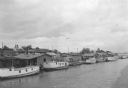
| Date: | 07 1936 |
|---|---|
| Description: | Elevated view of seagulls flying over fishing tugs moored at the wharf in Algoma. Small warehouse buildings line the wharf. Fish net drying reels are visib... |
If you didn't find the material you searched for, our Library Reference Staff can help.
Call our reference desk at 608-264-6535 or email us at: