 Filter: Subject of factories
Filter: Subject of recreation areas
Filter: Subject of factories
Filter: Subject of recreation areas

| Date: | 1882 |
|---|---|
| Description: | Bird's-eye views of various sections of Milwaukee. |

| Date: | 2007 |
|---|---|
| Description: | This map of Cedarbug is a bird's-eye map with 8 inset views and an index. The map is a print out of the original map dated 1892 held at the Cedarburg Cultu... |

| Date: | 1891 |
|---|---|
| Description: | Bird's-eye view of Eau Claire. |

| Date: | 1870 |
|---|---|
| Description: | Bird's-eye view of the city of Manitowoc with a population of 5,168 inhabitants as it appears in 1870, the year the village was granted a city charter by t... |
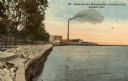
| Date: | 1918 |
|---|---|
| Description: | The Lake Michigan shoreline from Eichelman Park. In the distance is a smokestack and industrial buildings. Caption reads: "Scene on Lake Michigan from Eich... |

| Date: | 1910 |
|---|---|
| Description: | Elevated view of the Fox River Bridge. The building in the foreground has a sign that reads: "Chicago & Northwestern Railway. Freight Station." Caption rea... |
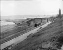
| Date: | 08 06 1917 |
|---|---|
| Description: | Overlooking the Chicago and North Western railroad depot from Juneau Park bluff. Caption on glass plate reads: "Extention [sic] of Juneau Park, show... |
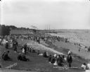
| Date: | 07 31 1921 |
|---|---|
| Description: | Crowds of individuals along South Shore Beach in the Bay View neighborhood. Some individuals are swimming while others are sitting on the grass and sand. ... |
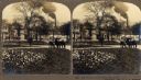
| Date: | 1903 |
|---|---|
| Description: | View of the Fourth Ward Park. Several men sit on a bench, while numerous houses and a factory are visible in the background. |

| Date: | 06 29 1937 |
|---|---|
| Description: | A man driving an International dump truck loaded with dirt is parked in front of a park area in Niagara Falls, Ontario, Canada. The sign on the door of the... |

| Date: | 1888 |
|---|---|
| Description: | This map has relief shown by hachures and features inset maps of a plat of E.D. Clinton and Blackwell’s add’n to the City of La Crosse. Wards (1-10) shaded... |

| Date: | 1883 |
|---|---|
| Description: | This map shows ward boundaries, names of additions, streets, bridges, mills, schools, religious buildings, businesses, hotels, railroads, factories, brewer... |

| Date: | 1935 |
|---|---|
| Description: | This map includes an index on the right margin of industrial plants, churches, schools, and public buildings. Streets, the Rock River, Lake Michigan, parks... |

| Date: | 1891 |
|---|---|
| Description: | This hand-colored map shows platted additions and subdivisions, ward boundaries, schools, churches, railroads, cemeteries, parks, businesses, factories, an... |

| Date: | 1931 |
|---|---|
| Description: | This map shows heavy industrial districts (yellow), commercial and light manufacturing districts (red), and residential districts (white) as well as a plat... |

| Date: | 2000 |
|---|---|
| Description: | This map shows the industrial area along the Menominee River and canals. Industrial buildings are shown in orange and labeled in red. Other areas are shown... |

| Date: | |
|---|---|
| Description: | Hand-colored view of a circular flower bed next to the river, with an interstate bridge in the distance. Caption reads: "One of the Many Pretty Flower Beds... |
If you didn't find the material you searched for, our Library Reference Staff can help.
Call our reference desk at 608-264-6535 or email us at: