 Filter: Subject of ferries
Filter: Subject of arts
Filter: Subject of ferries
Filter: Subject of arts
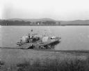
| Date: | 1921 |
|---|---|
| Description: | View from shoreline looking down at three men posing on a paddle steamer ferry boat carrying an automobile. The boat has the words "Cassville" and "Dewey" ... |

| Date: | 1915 |
|---|---|
| Description: | Ferry tied up at the Cassville dock. A number of men are standing along the shoreline. |
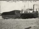
| Date: | |
|---|---|
| Description: | View from shoreline of a barge with four men standing on the deck. The ferry is carrying a large load. |

| Date: | 11 1781 |
|---|---|
| Description: | Map of New York, Staten Island, and Long Island, showing the placements of forts, and the movement of troops in 1776. The map also includes towns, cities, ... |

| Date: | 1789 |
|---|---|
| Description: | Map of New York City showing ward boundaries, ferries, streets, roads, swamps, ponds, and rivers. The properties of Lispinard, Byards, Jones, Rutgers, and ... |

| Date: | 1776 |
|---|---|
| Description: | Fairly detailed map of New York City and parts of Long Island. It shows streets, roads, wharves, ferries, ship yards, Fort George and the battery, public b... |

| Date: | 04 1777 |
|---|---|
| Description: | Map showing the area from Newtown, Pennsylvania to Kingston, New Jersey, with routes and battles of British (red) and American forces (blue). The map inclu... |

| Date: | 1795 |
|---|---|
| Description: | Map of South Carolina showing the precincts, cities, towns, Native American villages (marked with a triangle), courthouses, roads, mountains, swamps, islan... |
If you didn't find the material you searched for, our Library Reference Staff can help.
Call our reference desk at 608-264-6535 or email us at: