 Filter: Subject of ferries
Filter: Subject of railroads
Filter: Subject of ferries
Filter: Subject of railroads
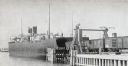
| Date: | 1899 |
|---|---|
| Description: | Chicago, St. Paul, Minneapolis & Omaha train cars loading onto car ferry Pere Marquette. |
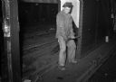
| Date: | 09 10 1946 |
|---|---|
| Description: | Young worker operates a large lever on railroad tracks. Part of a series on working conditions aboard Lake Michigan railroad car ferries. Ferry workers bel... |
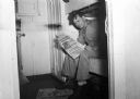
| Date: | 09 10 1946 |
|---|---|
| Description: | Worker reads union newspaper while sitting on a bunk and smoking a cigar. Part of a series on working conditions aboard Lake Michigan railroad car ferries.... |
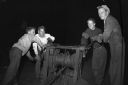
| Date: | 09 15 1946 |
|---|---|
| Description: | Four workers operating an "ancient" winch. Part of a series on working conditions aboard Lake Michigan railroad car ferries. Ferry workers belonged to the ... |
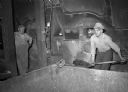
| Date: | 09 15 1946 |
|---|---|
| Description: | Workers shoveling coal into furnace. Part of a series on working conditions aboard Lake Michigan railroad car ferries. Ferry workers belonged to the Nation... |
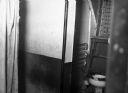
| Date: | 09 15 1946 |
|---|---|
| Description: | Workers' toilet. Part of a series on working conditions aboard Lake Michigan railroad car ferries. Ferry workers belonged to the National Maritime Union (N... |

| Date: | 1862 |
|---|---|
| Description: | This detailed map shows batteries and rifle pits, railroads, common and military roads, turnpikes, city streets and names, bridges, ferries, rural houses a... |

| Date: | 1939 |
|---|---|
| Description: | This nine-part map from the U.S. Bureau of Public Roads identifies federal and state highways in Wisconsin by pavement type. County, forest, park, and publ... |

| Date: | 1944 |
|---|---|
| Description: | This nine-part map from the U.S. Bureau of Public Roads identifies federal and state highways in Wisconsin by pavement type. County, forest, park, and publ... |

| Date: | 1911 |
|---|---|
| Description: | This map of Duluth and Superior shows street car routes, railroads, ferries, some points of interest, and lighthouses. The bottom left of the map reads: "C... |

| Date: | 1923 |
|---|---|
| Description: | This map shows portions of Minnesota, Iowa, Wisconsin, Illinois, Indiana, Ohio, Michigan, New York, Vermont, Massachusetts, Connecticut, Ontario, and Quebe... |

| Date: | 1936 |
|---|---|
| Description: | This colored road map shows automobile roads in Wisconsin as well as portions of Michigan, Iowa, Minnesota, and Illinois. U.S. numbered highways are shown ... |

| Date: | 1936 |
|---|---|
| Description: | This colored road map shows automobile roads in Wisconsin as well as portions of nearby states. U.S. numbered highways are shown in red, and information ab... |

| Date: | 1936 |
|---|---|
| Description: | This colored road map shows automobile roads in Wisconsin as well as portions of nearby states. Information on the quality and type of any given road (pave... |

| Date: | 1936 |
|---|---|
| Description: | This colored road map shows automobile roads in Wisconsin as well as portions of nearby states. Information on the quality and type of any given road (pave... |

| Date: | 1937 |
|---|---|
| Description: | This blue-line map of Wisconsin shows two maps of Wisconsin and the surrounding area, with a railroad map on one side and a road map on the other. The rail... |
If you didn't find the material you searched for, our Library Reference Staff can help.
Call our reference desk at 608-264-6535 or email us at: