 Filter: Subject of fish trade
Filter: Subject of rivers
Filter: Subject of fish trade
Filter: Subject of rivers

| Date: | 1867 |
|---|---|
| Description: | Birds-eye drawing of Appleton, Outagamie Co., depicting street names and street layout, houses, the Fox River, the court house, jail, school houses, Lawren... |
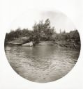
| Date: | 06 06 1894 |
|---|---|
| Description: | View from the river of fishermen's net and live-box at the shoreline. |
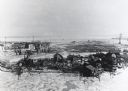
| Date: | |
|---|---|
| Description: | Elevated view of Jones Island fishing community in Milwaukee Harbor. Several shacks are visible as well as many fishing nets on net rollers. Ice on the wat... |
| Date: | 1938 |
|---|---|
| Description: | Elevated view of a boat owned by Julius Dettloff docked along the edge of a river. The boat was powered by an International PD-40 power unit; in the backgr... |

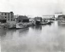
| Date: | |
|---|---|
| Description: | Fishing boats and a wharf along a canal. A bait shop is in the foreground. |

| Date: | 1964 |
|---|---|
| Description: | This map of Two Rivers shows the Rodgers street fishing area and land use. The map features a legend on the right of the types of land use. The map also sh... |
If you didn't find the material you searched for, our Library Reference Staff can help.
Call our reference desk at 608-264-6535 or email us at: